By Lynn Yarris
Berkeley Lab scientists have developed a new imaging technique that has the oil industry keenly anticipating its potential use in finding petroleum and natural gas reservoirs hidden beneath underwater bodies of salt.
Michael Hoversten and Frank Morrison, geophysicists with the Earth Sciences Division, working with Steven Constable, a marine geophysicist with the Scripps Institution of Oceanography at UC San Diego, are developing the technique, which is called "marine magnetotellurics" or marine MT. Based on the scattering of low-frequency electromagnetic radiation from the upper atmosphere by geological formations below the Earth's surface, marine MT is designed to augment seismic imaging in underwater geophysical surveys.
"We've found that these low-frequency electromagnetic fields are still recordable and capable of being used for sub-bottom imaging even at ocean depths of up to two kilometers," says Morrison, who is also a professor on the UC Berkeley campus.
With conventional seismic imaging, soundwaves are bounced off underground rock layers and reflected back to the surface where instruments record their travel time. This yields valuable information about rock formations and structures that can be used, among other purposes, to predict the presence and approximate size of petroleum and gas reservoirs.
 |
|
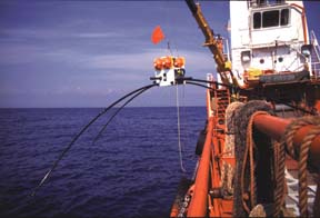
The marine MT device is lowered into the Gulf of Mexico for testing. The device detects low-frequency electromagnetic fields to create sub-bottom ocean images.
|
Seismic imaging, however, runs into problems in areas where the reservoir rocks underlie salt structures. Sometimes covering hundreds of square miles, these salt bodies are highly irregular in shape and excellent reflectors of soundwaves. These characteristics prevent surveyors from getting an accurate reading on the thickness and shape of the underside of the salt.
Salt is also highly resistant to the flow of electrical current, a fact that marine MT exploits through the utilization of naturally occurring ultra-low-frequency radiation caused by the interaction of the solar wind and the earth's magnetic field. The result of this is electromagnetic waves and associated currents that penetrate deeply into the earth's crust. By measuring both magnetic fields and the resulting electric fields, geophysicists can learn about the properties of individual rock strata.
"The electrical resistivity of salt is often more than 10 times greater than that of the surrounding sediments" says Hoversten. "By measuring the distortion in the flow of electrical currents through seawater and sediment produced by the presence of salt, we can easily map major structures and resolve questions not answered by seismic imaging. In this manner, marine MT provides us with complementary as well as independent information."
Hoversten, Morrison, and Constable conducted tests in the Gulf of Mexico where huge oil and gas reservoirs are believed to be hidden under vast expanses of salt.
Marine MT surveys were conducted over two sites, known as "Mahogany" and "Gemini," where the prospects for finding oil and gas are rated good. Mahogany is a relatively shallow water site, about 100 meters in depth, off the Louisiana coast. Gemini is further off-shore in water as deep as 1.5 kilometers (nearly 5,000 feet). The device used to measure underwater electrical resistivity consists of an x-shaped frame packed with electrodes and special magnetic field sensors which were developed at Berkeley Lab and are among the most sensitive ever made.
To this assembly is added a buoyancy chamber and a concrete anchor. The complete package, which looks somewhat like a four-legged spider the size of a small raft, gets dropped overboard off a ship, sinks to the sea floor, and remains in the sediment for a couple of days. A remote signal is then used to detach the anchor from the frame, and the floatation chamber brings it to the surface. Typically, ten or more similar assemblies would be deployed during a single survey leg.
"This is the first time where MT instrumentation has been successfully deployed and retrieved from deep water," says Hoversten who credits Constable and his colleagues at Scripps for the design of the marine equipment. The Scripps researchers believe their assembly will operate in water depths up to five kilometers (16,500 feet).
 |
|
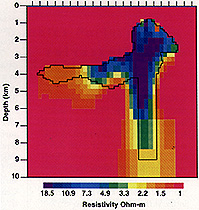
A two-dimensional inversion of numerical data from a deep rooted salt structure, clearly showing the presence of the deep root.
|
Data from the Mahogany and Gemini surveys are still being processed, but Hoversten says he and Morrison are confident of its potential for mapping the extent and thickness of salt structures with sufficient resolution to gauge the prospects for oil or gas in the underlying sediment.
"Most of the undiscovered oil and gas in the Gulf and other bodies of water throughout the world are hidden under salt or other problem rocks, such as basalt and carbonates, that make seismic prospecting difficult to apply," says Hoversten. "By showing where and how deep the possible pay zones are, marine MT can go a long way toward helping a company pick its drilling targets."
The cost of marine MT pales before the cost of drilling or even the cost of seismic imaging. Marine surveys are divided into "blocks," each of which constitutes an area of three square miles. It costs about $500,000 to survey one block with seismic imaging and about $50,000 to survey it with marine MT.
Marine MT technology research is partially sponsored by the Department of Energy's Office of Computational and Technical Research, and the erltr Partnership Program. The surveys of the Mahogany and Gemini sites in the Gulf of Mexico were funded by a consortium of oil companies including AGIP, Chevron, BP, BHP, and Texaco.