When concentration distributions can be reliably predicted from area to area, efforts can be focused on monitoring those homes expected to have especially high amounts of radon and therefore the greatest potential for inducing lung cancer in occupants. Without such a focused effort, a nationwide program would be extremely -- perhaps prohibitively -- costly.
Radon-222, the most significant isotope, is produced by the radioactive decay of radium-226, which in turn is produced by the decay of trace amounts of uranium-238 found in the earth's crust. Since radon enters buildings in soil gas, indoor concentration depends on such factors as soil radium content and permeability to gas flow. House characteristics, such as the configuration of the substructure, and weather conditions also play a role.
Studies by Nero and his coworkers have shown that a small but significant number of houses have concentrations much larger than the national average of one picocurie per liter (pCi/l). One to three percent of houses (about one million U.S. homes) have concentrations above 8 pCi/l, a level at which occupants are receiving a radiation dose greater than the average for uranium miners. In 50,000 to 100,000 homes, concentrations exceed 20 pCi/l, causing occupant exposures near or above the occupational radiation dose limit. About 90 percent of these are believed to be located in 10 percent of the country.
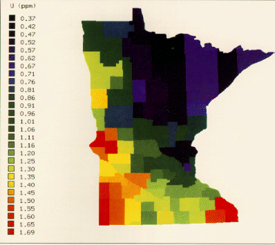
In a demonstration case in Minnesota, LBL researchers found that radiometric data obtained from previously conducted aerial surveys, combined with geologic data from soil permeability studies, correlated highly with direct in-home radon measurements. By using data on each county's average radium concentration to predict the county's average indoor radon concentration, the researchers can identify areas where homes should be monitored and where remediation efforts, such as modifying substructure ventilation, should be carried out.
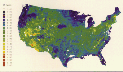
The long-term aim of Nero and his coworkers is to estimate average local concentrations across the nation, down to a census-tract scale (4000 people).
The ultimate outcome will be a decrease in the incidence of lung cancer. Currently in the United States, as many as 10,000 cases of lung cancer per year may be caused by radon exposure, a very large number compared to the estimated risk from other environmental pollutants.