|
April 22, 2002
|
|
 |
 |
| Mapping Yucca Mountain's Subterranean Water Flow | ||
| Contact: Dan Krotz, dakrotz@lbl.gov | ||
|
|
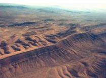
Yucca Mountain lies in a remote desert region about 100 miles northwest of Las Vegas, Nevada. On the surface, it is usually bone dry. To find out if water from occasional rain seeps into the mountain, you'll have to look hundreds of meters underground. And to understand how water moves through the mountain, you'll have to ask researchers in Berkeley Lab's Earth Sciences Division.
Geologists with the division's Nuclear Waste Program are evaluating Yucca Mountain as a potential radioactive waste repository. The team's job is to determine if water, which percolates through fractures and porous rock, could transport nuclear waste to the water table half a kilometer deep and eventually lead to human exposure far away. To do so, they take geological data collected from maps, deep boreholes, and tunnels, and develop computer models that portray how water flows through layers of rock. Their rationale is simple. At first glance, earthquakes and volcanic eruptions loom as the most obvious concerns when evaluating the long-term viability of an underground waste disposal site. But these events, however violent, aren't guaranteed. The biggest concern is water. It's mobile, it corrodes and dissolves, it can transport radioactive particles, and it's ever present.
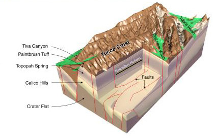
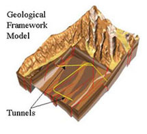
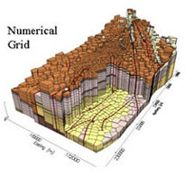
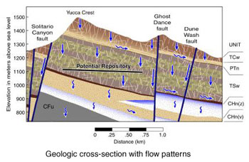
The trick is to understand how water moves deep inside Yucca Mountain, and use this knowledge to predict how conditions within the mountain will respond to different climates over the next 10,000 years. To do this, the researchers first must journey back in time about ten million years, when a series of volcanic eruptions deposited layers of ash on what is now Nevada. Some of the ash gently settled on the ground and cooled to form porous rock. Other eruptions sparked massive, gaseous ash flows. These flows compressed and condensed under their own weight to form dense rock. As it cooled, the dense, brittle rock fractured, creating a labyrinth of interconnected and dead-end cracks. Over time, these layers were uplifted by tectonic activity and eroded by wind and water to form a complex Yucca Mountain. Today, the characteristics of these layers dictate how water moves deep underground. Take porous rock. It acts like a sponge: under relatively dry conditions, it holds water. But add more water, as during a wet climate, and the rock gradually becomes more saturated; gravity allows the water to slowly percolate deeper underground. In contrast, dense rock has less pore space to hold water like a sponge. However, these rocks contain abundant fractures and are also subject to changing flow patterns based on the volume of infiltrating water. Under dry conditions, very few fractures carry water. But as infiltration increases, more fractures may participate in groundwater flow. "Given the variability of rock properties at the site, understanding the nature of flow within the mountain is a constant challenge," says Berkeley Lab's Jennifer Hinds (now at the University of Idaho). "We continue to explore new ways to collect and analyze data that enable us to refine our conceptual understanding and improve our computer models." More specifically, Berkeley Lab geologists and hydrologists are developing a model comprised of two broad components. First, there is a framework model that describes the position of the rock layers and faults. Second, there are the hydraulic properties and infiltration rates that govern how water flows through these rock layers. Combined, these two components help determine whether water, over time, can percolate into the storage site and transport radioactive material.
"Our objective is to characterize the Yucca Mountain flow system as it is today, and to predict future behavior to thermal disturbances and climate change," Hinds says. "We need to answer many questions: How fast does water move? What is the general flow pattern? And how isolated will the waste be from water?" To find the answers, the model must be incredibly complex. In addition to rock layers, there's also climatic change. Nevada is arid today, but a wetter climate would significantly increase the amount of water that penetrates underground. To portray these changes, a range of surface infiltration maps that are based on current and historic climate data are incorporated into the model. This information is used to predict how future glacial and interglacial periods will impact groundwater flow at Yucca Mountain. The model also includes mineral and geochemical data that determine whether radioactive material will be absorbed by the surrounding rock and removed from the water flow. Add other variables such as saturation levels, temperature, and air pressure — and the model begins to mirror the vast web of phenomena that shape how water flows underground.
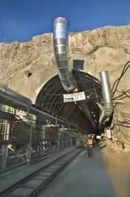
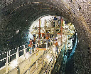
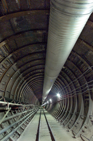
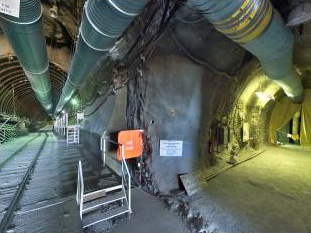
Surface maps and small-diameter boreholes provide a glimpse of what is happening deep underground. But by far the most direct insights come from underground tunnels excavated at Yucca Mountain. The 25-foot wide tunnels cover a distance of about seven miles as they cut through different rock types, fractures, and fault zones. The tunnels reach depths of more than 200 meters, which allows scientists to observe and test the rock layers that will potentially house the radioactive waste. Several smaller tunnels branch off from the main tunnels, allowing access to room-size cross sections of rock for additional testing and data collection.
"The tunnels provide important geologic information for building a framework model. In addition, underground testing of air and water movement help constrain the rock properties used in our model simulations," says Hinds.
Recently, Hinds developed a way to bring this underground testing facility to the office. She and Roy Kaltschmidt, of Berkeley Lab, photographed portions of the tunnel, and used these photographs to develop a three-dimensional virtual tour of the site. Now, scientists can walk through the tunnel while sitting at their computer. They can focus in on a section, and even pan around 360 degrees. "Our goal with the virtual tour is to develop a visually interactive educational tool to communicate our research activities to both scientists and nonscientists alike," says Hinds.
Additional information: More about exploring the geology of Yucca Mountain
|
|||||||||||||||||||||||||||||||||||||||||