| February 15, 2002 |
|
 |
 |
| A "LITTLE ROBOT THAT COULD" TRACKS PLANKTON GROWTH IN STORMY ANTARCTIC WATERS | |
| Contact: Paul Preuss, (510) 486-6249, paul_preuss@lbl.gov | |
|
|
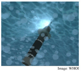
BERKELEY, CA � A deep-diving SOLO float, specially
equipped by scientists at Lawrence Berkeley National Laboratory to report
on biological activity in the sea, has faithfully tracked a plankton bloom
for over 200 kilometers through the stormy Southern Ocean — even
helping the ship that fertilized the plankton growth with iron relocate
the same watery patch three weeks later.
Three times each day two of the SOLO floats, the one inside the patch and another outside, acting as a control, dive up and down several hundred meters to measure particulate carbon — most of it in the form of phytoplankton, or single-celled algae. The floats return to the surface daily and, weather permitting, report their Global Positioning System (GPS) positions and data to satellites overhead. SOFeX: making the Southern Ocean bloom The purpose of SOFeX, the Southern Ocean iron (Fe) experiment, is to test the late John Martin's "iron hypothesis." While director of MLML, Martin proposed that phytoplankton blooms can lower global temperature by removing carbon from the atmosphere. Since phytoplankton needs iron from sources like windblown dust to grow, Martin famously remarked "Give me half a tanker of iron, and I will give you an Ice Age." The prospect of controlling atmospheric carbon through ocean fertilization and perhaps offsetting global warming are matters of intense interest to the Department of Energy and the other agencies and institutions participating in SOFeX. Consequently, under the scientific direction of MBARI's Ken Johnson, R/V Revelle pumped an iron solution (somewhat less than half a tankerful) overboard in two regions of the Southern Ocean along 170 degrees west longitude. The waters of the more northerly region, at about 55 degrees south latitude — the "howling 50s" of seagoing lore — are poor in the silicate that some phytoplankton need to form a shell. Thus plankton in that patch were expected to bloom sluggishly even after iron fertilization, while a more vigorous bloom was expected after fertilization of the silicate-rich (and iceberg-crowded) waters of the southern patch, at about 66 degrees south. After Revelle "pumped iron" into these regions, Melville, led by principal SOFeX investigator Kenneth Coale of MLML, followed to measure changes in phytoplankton growth. Soon the Polar Star, under the scientific direction of Ken Buesseler of the Woods Hole Oceanographic Institution, will visit the southern patch to begin assessing long-term carbon uptake. Testing the waters
To measure particulate carbon the robotic floats follow depth profiles that can be programmed and reprogrammed via satellite from virtually anywhere in the world. The floats surface daily to signal their positions and send data, saving up to 11 depth profiles if high winds interfere with transmission. Revelle started its voyage with our SOLO floats. One of the first two in the northern patch, designated SOLO2054, promptly drifted west when the fertilized water mixed and divided. The center of the main patch was recalculated and a third float, SOLO2104, was launched. "We had programmed the depth profiles to keep the floats at a depth of 100 meters most of the time, instead of periodically 'resting' them at depth," Bishop explains. "We were a bit apprehensive, however, that by staying in the middle of the plankton bloom, the instruments — which measure particulate matter by how much light is transmitted through the water — might become fouled."
Revelle headed south to fertilize a second patch of ocean. Fair skies there soon turned stormy. Because of its far-south location in the southern patch, the fourth and final SOLO float suffered raging storms and reduced satellite coverage. Heard from only once before February 14, that float reestablished contact and played back all its past profiles when the winds finally moderated. Programming pays off "Our guess at how to program SOLO to stay with the patch seems to have paid off in a big way," Bishop says. "SOLO2104 has remained at or very near the center of the patch since it was deployed, and the control SOLO has maintained position nearby." Revelle returned to the northern patch on February 7, guided by SOLO2104's accurate GPs coordinates. Just before arrival, the ship finally received the first color image of the area in over three weeks, from NASA's SeaWIFs satellite. The highest concentration of plankton was found near the float's position, saving the ship enough search time, Bishop estimates, "to more than pay for the floats."
Although winds throughout the region had exceeded 20 knots most of the
time, and SOLO2104 was unable to transmit during the worst storms, "it
played back its data faithfully afterwards," Bishop says. "We
also have an almost unbroken record from the control SOLO, to make this
part of the experiment a major success." Despite expectations that
growth in the northern patch would be poor, "We can confidently say
that particulate organic carbon in the patch has grown to be four or five
times that outside the patch." Revelle returned to dock in New Zealand on February 14, but the SOLO floats have enough power to continue profiling for at least three or four more months, long after ships have left the region. The information they report will play a crucial role in assessing the possible role of ocean fertilization in regulating carbon in the atmosphere through ocean carbon sequestration. Berkeley Lab is a U.S. Department of Energy national laboratory located
in Berkeley, California. It conducts unclassified scientific research
and is managed by the University of California. Additional information:
|
|||||||||||||||||||||||