|
February 15, 2002
|
|
 |
 |
| Berkeley-Trent: A BETR model of toxic transport | ||
| Contact: Dan Krotz, dakrotz@lbl.gov | ||
|
|
To better understand how contaminants such as pesticide travel across the continent, researchers from Berkeley Lab and Canada's Trent University have incorporated into a single model toxic release data, wind and water current patterns, and regional differences such as soil and vegetation. The BETR model, which derives its name from the two institutions involved, improves on traditional atmospheric models by more completely reflecting how persistent organic pollutants move and accumulate throughout North America. Chiefly, contaminants such as dioxin, DDT, and mercury don't simply drift with prevailing winds. They're also absorbed by the soil, water, and vegetation because of a natural tendency to maintain equilibrium with the environment. Whenever a persistent pollutant drifts into a region, a percentage of it penetrates into the landscape until its air, soil, vegetation, and water concentrations are in balance. If a new air mass containing the same pollutant moves in, the equilibrium is unbalanced and some of the absorbed compound is released until a new homeostasis is attained.
"This is how contaminants leapfrog across the continent, and why air transport models don't really work for many persistent organic pollutants," says Tom McKone of Berkeley Lab's Environmental Energy Technologies Division. In addition, because persistent pollutants are continuously absorbed and reabsorbed as they drift with prevailing winds, conventional air tests can easily underestimate the amount of contaminant in an area. At any given time, most of the pollutant may be in the soil, not in the air. To account for contaminants' complex jitterbug across the continent, McKone's research group and his Trent University colleagues divided North America into 24 regions largely based on watershed and soil type. In the Midwest, for example, the Missouri and Cheyenne Rivers watershed region is neighbored to the south by the Arkansas River-High Plains region. Each region is further subdivided into seven compartments: upper atmosphere, lower atmosphere, vegetation, soil, fresh water, coastal water, and freshwater sediment. The characteristics of these compartments enable the model to determine how each region absorbs a specific contaminant. For example, soil absorbs chemicals based on its organic carbon content, water content, and porosity, so a loamy soil absorbs chemicals differently than a clay soil. Likewise, saltwater absorbs chemicals differently than fresh water. And with vegetation, the more lipid contained in the leaves of a region's plants, the more a fat-soluble chemical is absorbed. Much like a chemical equation, the model pits the absorption traits of each region's compartments (air, soil, etc.) against the solubility of a specific contaminant. So, if airborne dioxin drifts into the Great Lakes Basin region, the model runs seven mass balance equations -- one for each equilibrium relationship between dioxin and the region's seven compartments -- until the relative amount of dioxin in the air and environment is calculated. To give the model a continental scale, a database of hydrological and meteorological information determines how wind, rivers, and coastal water ferry contaminants from region to region. By overlaying this transport data onto 168 mass balance equations (seven for each of the 24 regions), the model maps the pathway and eventual fate of a contaminant as it's transported across North America.
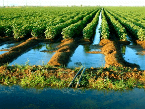
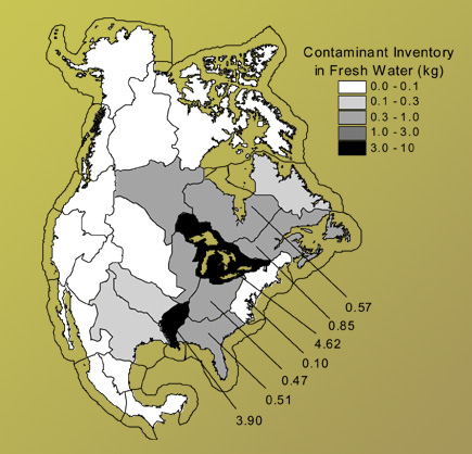
So far, the model has been tested using real-world data associated with toxaphene, a banned pesticide that was once widely used on cotton crops in the Southeast and is now found in high concentrations in the Great Lakes. The team introduced a hypothetical 10,000 kilogram-per-year release in the lower atmosphere compartment of the Mississippi Delta region, and the model determined that although the compound spread throughout much of North America, the highest concentrations accumulated in the Great Lakes. "The model reproduces what we see in the real world," McKone says. The next step is to use the model to map human exposure, McKone says. Although the BETR model tracks exposure based on inhalation, drinking water, and skin contact, it can't account for the incredibly complex dynamics that affect food-based exposure. A person can buy an apple in Chicago that was grown in Washington State but contaminated by pesticides from Mexico. To reflect this complexity, the mass balance of pollutants has to be coupled with the mass balance of food. In other words, determine where a region's fish, meat, milk, produce, and grains are imported from, and backtrack to the source regions to determine how much contaminant each food absorbed. McKone believes such a food-pollutant web will enable EPA officials to not only determine whether there's too much pesticide in Chicago's produce, but where the produce came from, and most importantly, where the pesticide originated -- the root cause of the problem. "The BETR model of contaminant fate is very important, but it's
an exercise in environmental chemistry," McKone says. "We can
add human exposure data to the model and help to better inform regulatory
policy." Additional information:
|
||||||||||||||||