|
1.0 Summary This assessment examines potential impacts on federally listed plant and animal species that could result from the construction and operation of the proposed Field Research Center (FRC) by the Department of Energy (DOE) on the preferred site on the Oak Ridge Reservation (ORR). The species considered in this assessment are those listed in the letter from the U.S. Fish and Wildlife Service to the U.S. Department of Energy, dated September 14, 1999 (FWS 1999a) and included in Appendix D of the Draft Environmental Assessment for the proposed project (DOE 1999). These listed species are the endangered gray and Indiana bats. DOE staff concludes, for the reasons described in the main text of this assessment, that the proposed project is not likely to adversely affect either species. Also, since no proposed or designated critical habitats are present on the site, none would be affected. The FWS expressed concurrence with this conclusion in a letter dated February 10, 2000 (FWS 2000). This assessment is intended to finalize concurrence. Introduction and Project Description The proposed FRC would include a 243-acre (98-ha) previously disturbed contaminated area and a 404- acre (163-ha) background area on and adjacent to the Y-12 Site. The proposed contaminated area would be used for conducting experiments on contaminated groundwater and subsurface sediments. The proposed background area would provide for comparison studies in an uncontaminated area. The proposed contaminated area and background areas would be located in Bear Creek Valley (BCV). The BCV is approximately ten miles (16 kilometers [km]) long and extends from the eastern end of the Oak Ridge Y-12 Site to the Clinch River on the west. Bear Creek is a tributary to East Fork Poplar Creek, which drains into the Clinch River at the East Tennessee Technology Park. Except for the extreme eastern end of the contaminated area of the proposed FRC, the area is outside of any security fences, adjacent to public use roads, but protected from unwarranted passersby. There would be no new building construction needed for operation of the FRC; only minor land disturbance would be involved, for the installation of wells. Ecological Description of the Sites The following brief description is taken from DOE (1999) unless otherwise noted. This description has been verified with field reconnaissance by the author (J.W. Webb, ORNL, personal observations, February, 2000). Before 1940, most of BCV was cleared and used for agriculture. Currently, about 65 percent of the BCV watershed is wooded, with common vegetation being predominantly oak and oak-hickory associations on the upper slopes and ridgetops and planted pine along the creek and floodplain area. Old field and grassland habitats are also present. Thus, elements of the majority of wildlife habitat types and the expected terrestrial fauna found on the ORR occur in BCV. Hardwood and mixed hardwood/conifer habitats are the most abundant of the habitat types in the Bear Creek watershed, followed by pine plantation and grassland habitats, with considerable riparian habitat along the length of Bear Creek.
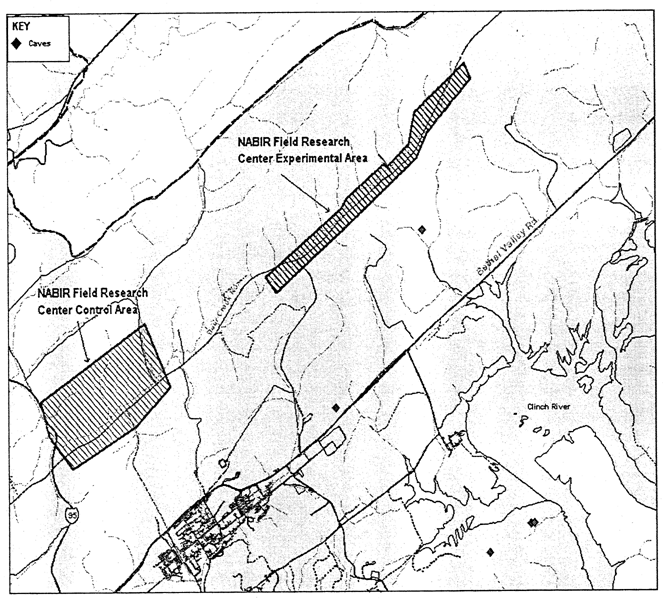
Figure G-1 Existing bat caves in the proposed FRC The proposed contaminated area is primarily characterized by dense stands of planted pines and smaller areas of densely spaced mixed hardwoods. The creek and riparian zone are narrow and located near the paved Bear Creek Road. Trees in the proposed contaminated area are generally less than 20 cm diameter at breast height (dbh) and do not exhibit exfoliating bark; Indiana bats require larger trees with loose bark as maternity roost sites. Some snags are present, primarily a result of wind activity in these exposed stands. In contrast, the proposed background area is primarily mixed hardwoods and has larger trees (>70 cm dbh) of a variety of species. Spot checks in the proposed background area (Webb, personal observations) showed the presence of both snags and trees with exfoliating bark, particularly in the riparian zone of Bear Creek; these are potential roost sites for Indiana bats. Bear Creek completely traverses the length of both the proposed contaminated area and the background area, and thus includes the associated section of 100-year floodplain and associated riparian habitat. The creek is narrow (i.e., < 1 m) and channelized in its upper reaches, including much of the proposed contaminated area. In the proposed background area, the creek is frequently several meters wide and meandering. Bear Creek has been quantitatively monitored and has been designated as having a degraded fish community especially in headwater locations, where most of the proposed contaminated and background areas are located. Benthic invertebrate fauna collections show a similar pattern with a diverse benthic fauna well established at downstream locations (outside the proposed FRC areas) and a depauperate benthic community within the proposed contaminated and background areas adjacent to Bear Creek. Recent research has indicated an improvement in species diversity within the upper reaches of Bear Creek; however, the fish population is still considered impaired. Neither the FRC field office nor laboratory structures would be located in the BCV floodplain. 3.1 Listed Species and Potential Impacts of the Project The general ecology of federally listed species that may occur on the site (FWS 1999a) and the expected impacts from the project on them are summarized below. Unless otherwise noted or referenced, general biological information on the species is derived from Harvey (1992). 3.1.1 Gray Bat (Myotis grisescens) The endangered gray bat is concentrated in cave regions of Arkansas, Missouri, Kentucky, Tennessee, and Alabama. Although the population is over 1.5 million and improving, about 95 percent hibernate in only eight known caves, two of which are located in Tennessee. During the summer gray bats are usually found in caves, though frequent different caves than those used for hibernation. Females form maternity colonies of at least several hundred individuals, while males and non-reproductive females form smaller summer bachelor colonies. Summer caves, especially for maternity colonies, are rarely more than three km (two miles) and usually less than 1.6 km (one mile) from the rivers and lakes used as foraging areas. During the spring and autumn transient periods the bats occupy a wider variety of caves. During all seasons males and yearling females seem less restricted to specific caves and roost types. In general, bats enter hibernation in September through October and emerge in late March and April; timing depends on age and gender. Young are born in late May or early June. Bats forage over water, mostly along rivers, large creeks, and lakes, primarily within about five m (15 feet) above the surface. Gray bat populations are on the upswing as a result of improved breeding success due to better protection measures, such as cave gates, fences and informational signs near caves. The nearest caves to either of the proposed FRC areas are about one, two, and five km from the proposed contaminated area , slightly further from the proposed background area . The latter two of these, Walker Branch cave and Big and Little Turtle caves, were surveyed by Mitchell et al. (1996) and no gray bats were found. There is an unverified report of ten gray bats roosting in Little Turtle cave (located about 5 km from the sites) in September, 1996, as referenced in FWS (2000). These bats were observed roosting and were not further disturbed; thus, a definite, in-the-hand identification was not made (J.W. Webb, ORNL, personal communication with Deborah Awl, JAYCOR, September 18, 1996). If indeed gray bats, they quite likely were bachelor males en route to a hibernation site, although they could also have been entering hibernation in that cave. In November 1994, a single dead gray bat was found in a display case in a building at the Y-12 plant northeast of the proposed contamination site. This individual was probably an isolated individual juvenile which became lost, disoriented, and trapped. In August 1995 a live bat was found in a building at Y-12, but it was released before a positive identification was made. Based on the attachment of the wing membrane to the ankle as shown in photographs of this specimen, I do not think it was a gray bat (Webb, personal observations.) Mist netting, in which I assisted, was conducted by Harvey on the lower portion of East Fork Poplar Creek and its tributaries in May 1992 and again in May - June, 1997 (Harvey 1997). The 1997 survey included portions of lower Bear Creek near its confluence with lower East Fork Poplar Creek; this location is about 4 km from the proposed FRC areas . The creeks in this area provided good gray bat foraging habitat and excellent Indiana bat summer roosting and foraging habitat at the time of the surveys. No gray or Indiana bats were recorded among six species captured. Although caves less than 5 km from the sites are not known to harbor gray bats, it is still possible that bats could forage on the sites, primarily along the stream corridor of Bear Creek. Within the contaminated area, the creek is narrow and suboptimal for frequent foraging by gray bats. Within the background area, the stream corridor is suitable, although there is better habitat along the Clinch River and the lower reaches of Poplar Creek and East Fork Poplar Creek; these latter three areas are probably also nearer to likely roost caves. As reported above, the aquatic insect fauna of Bear Creek is suboptimal, again suggesting that the creek and its riparian zone may not provide an ideal foraging area. In any case, the only creek-related activities associated with proposed FRC research would involve sampling within the creek and possible well installation within the riparian zone. These activities would involve minimal clearing at most, and would be conducted during the day, so that any foraging by gray bats would therefore not be disrupted. Thus, I conclude that the project is unlikely to adversely affect the gray bat or its habitat. 3.1.2 Indiana Bat (Myotis sodalis) The range of the endangered Indiana bat is in the eastern U.S. from Oklahoma, Iowa, and Wisconsin east to Vermont and south to northwestern Florida. Distribution is associated with major cave regions and areas north of cave regions. The present total population is estimated at ca. 352,000, with more than 85 percent hibernating at only nine locations – two caves and a mine in Missouri, three caves in Indiana, and three caves in Kentucky. Indiana bats usually hibernate in large dense clusters of up to several thousand individuals, in sections of the hibernation cave where temperatures average 38 - 43 F and with relative humidities of 66 to 95 percent. They hibernate from October to April, depending on climatic conditions. Density in tightly packed clusters is usually estimated at 300 - 484 bats per square foot. Female Indiana bats depart hibernation caves before males and arrive at summer maternity roosts in mid May. A single offspring, born during June, is raised under loose tree bark, primarily in wooded streamside habitat. Maternity colonies use multiple primary roost trees that are used by a majority of the bats most of the summer and a number of secondary roosts that are used intermittently and by fewer bats, especially during periods of precipitation or extreme temperatures. Thus, there may be more than a dozen roosts used by some Indiana bat maternity colonies (FWS 1999b). Kurta et al. (1996) found that female Indiana bats may change roosts about every three days, and a group of these bats may use more than 17 different trees in a single maternity season. During September, they depart for hibernation caves. The summer roost of adult males is often near maternity roosts, but where most males spend the day is unknown. Other males remain near the hibernaculum. A few males can be found in caves during summer. Until relatively recently, little was known about the summer habitat and ecology of the Indiana bat. The first maternity colony was discovered in 1974, under the loose bark on a dead butternut hickory tree in east central Indiana. The colony, numbering about 50 individuals, also used an alternate roost under the bark of a living shagbark hickory tree. The total foraging range of the colony consisted of a linear strip along approximately 0.5-mile of creek. Foraging habitat was confined to airspace from 6 feet to ca. 95 feet high near the foliage of streamside and floodplain trees. Two additional colonies were discovered during subsequent summers, also in east central Indiana. These had estimated populations of 100 and 91 respectively, including females and pups. Habitat and foraging area were similar to the first colony discovered. Additional evidence gathered during recent years indicates that, during summer, Indiana bats are widely dispersed in suitable habitat throughout a large portion of their range. Using radio telemetry techniques, several additional maternity colonies have recently been discovered and studied at several locations. These studies reinforced the belief that floodplain forest is important habitat for Indiana bat summer populations. However, maternity colonies were also located in more upland habitats. It was also discovered that Indiana bats exhibited fidelity to specific roosting and foraging areas to which they returned annually. Between early August and mid September, Indiana bats arrive near their hibernation caves and engage in swarming and mating activity. Swarming at cave entrances continues into mid or late October. During this time, fat reserves are built for hibernation. It is thought that Indiana bats feed primarily on moths. A longevity record of 13 years 10 months has been recorded for this species. Hibernating bats leave little evidence of their past numbers; thus, it is difficult to calculate a realistic estimate of the overall population decline for this species. However, population estimates at major hibernacula indicated a 34 percent decline in the total Indiana bat population from 1983 to 1989. The only record of Indiana bats on the ORR is from a single specimen in the 1950s (FWS 2000). No maternity roosts have been located on the ORR, or indeed yet in Tennessee (FWS 1999b). In general, limited information suggests that the bats roost primarily north of their hibernacula and more often in the northerly parts of their range. During mist netting on lower East Fork Poplar Creek and its tributaries, described above for gray bats and in Harvey (1997), no Indiana bats were captured out of six species recorded. Habitat on the proposed contaminated area of the FRC does not appear to provide suitable roosting habitat, and foraging habitat there is suboptimal as described above for gray bats. The proposed background area, however, does provide apparently suitable roosting and foraging habitat, although the site has not been completely characterized in this regard (Webb, personal observations, February 2000). Because only minor land-disturbance would occur within 100 feet of the stream, roosts, if present in the riparian zone, would not likely be disturbed. Though less likely, a roost also might be present in an upland area. Were a roost to occur near drilling, then noise and other activities might disturb Indiana bats. The severity of any such adverse effects would depend on specific circumstances. Effects on foraging would be unlikely because activities would occur during the day. Thus, current knowledge, including recent surveys on the ORR in optimal habitat, suggests that it is unlikely that Indiana bats would be present on either site; if present, it is unlikely that project activities would adversely affect them. 4.0 References DOE (U.S. Department of Energy). 1999. Environmental Assessment for Selection and Operation of the Proposed Field Research Centers (DRAFT). December 22, 1999. FWS (Fish and Wildlife Service, Department of Interior). 2000. Letter from Dr. Lee A. Barclay, FWS, to Mr. Paul E. Bayer, DOE, February 10. Letter from Dr. Lee A. Barclay, FWS, to Mr. Paul E. Bayer, DOE, September 14, 1999a. Agency Draft Indiana Bat (Myotis sodalis) Revised Recovery Plan. Columbia, Missouri, April 1999b. Harvey, Michael J. 1992. Bats of the Eastern United States. Arkansas Game and Fish Commission and U.S. Fish and Wildlife Service. February. 46 pp. Harvey, Michael J. 1997. Survey for endangered and threatened bats on Parcel ED-1, Oak Ridge Reservation. July. 24 pp. Kurta, A., K. J. Williams, and R. Mies. 1996. Ecological, behavioural, and thermal observations of a peripheral population of Indiana bats (Myotis sodalis). Pages 102-117, in R. M. R. Barclay and R. M. Brigham, editors. Bats and Forests Symposium. Research Branch, Ministry of Forests, Province of British Columbia, Victoria, British Columbia. Mitchell, J. M., E. R. Vail, J. W. Webb, J. W. Evans, A. L. King, P. A. Hamlett. 1996. Survey of protected terrestrial vertebrates on the Oak Ridge Reservation, Final Report. Oak Ridge National Laboratory, Oak Ridge, Tennessee, ES/ER/TM-188-R1.
|