|
February 15, 2002
|
|
 |
 |
| Tracing the movement of pollutants with BETR North America, a continental-scale contaminant fate model | ||
| Contact: Allan Chen, a_chen@lbl.gov | ||
|
|
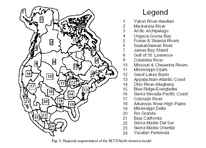
Whether they are dissolved in water, sorbed to particles or gaseous, pollutants can travel in the environment. Some move thousands of miles from their point of origin, crossing oceans and continents. Many also cross media, traveling as a gas, perhaps dissolving in rain droplets or lakes and streams, then finding their way into soils, plants, animals and humans. To researchers studying the risks to human health posed by chemicals like pesticides, and the organic products of industrial processes and combustion, tracking the movement of these chemicals through the environment is a challenge. Now a collaboration between researchers at Berkeley Lab's Environmental Energy Technologies Division and Trent University's Canadian Environmental Modeling Center in Canada has resulted in a computer model capable of simulating the long range transport (LRT) and cross media transfers of pollutants throughout the north American continent. BETR North America, the BErkeley-TRent model, is the first designed to evaluate the fate of these multimedia pollutants at the continental scale. "The long-range transport of simple gases such as nitrogen oxides, sulfur oxides, ozone, and carbon dioxide have been extensively studied," says Thomas McKone, Senior Scientist at Berkeley Lab, and Adjunct Professor at UC Berkeley's School of Public Health, "but the movement and impacts of multimedia pollutants are still poorly understood." Multimedia pollutants such as the persistent organic pollutants (POPs) can transfer or partition among the atmosphere, airborne particles, the soil surface, water, and vegetation, and can ultimately accumulate in living organisms. Better health risk assessment of these pollutants requires a better understanding of their transport from a source or specific region throughout the environment. Managing chemicals that are subject to LRT is also a challenge for policy makers, since these chemicals can originate in one jurisdiction, and end up accumulating in other physically distant regions. Most other existing models are scaled at roughly several hundred miles square, not large enough to address the North American continent as a whole. BETR models North America's environment as a group of 24 ecological regions with boundaries based on geographic features mainly waterways and soil types (see figure 1).
The environment within each region is modeled as a system of seven compartments: upper atmosphere, lower atmosphere, vegetation, soil, fresh water, coastal water and freshwater sediment. A database of hydrological and meteorological data provides the basis for modeling transport between regions in the atmosphere, freshwater and coastal water media. The data are compiled with the help of a geographical information system. Seven equations describe the contaminant fate in each region of the model, so 168 mass balance equations are needed to apply the model to the 24 regions of North America. The model's structure is flexible enough to be adapted to other large continental areas such as South America, Europe or Asia. Figure 2 is an example of the model's output, showing the distribution of the now-banned pesticide toxaphene. Once used extensively in the southeastern United States, toxaphene is a widely-studied persistent organic pollutant. Researchers suspect that it is accumulating in the Great Lakes and their aquatic food chains as the pesticide evaporates from the soils in which it was deposited. The figure shows the steady-state distribution of toxaphene throughout the 24 regions as a result of a hypothetical release of 10,000 kg/year to the lower air compartment of the Mississippi Delta region.
"We are currently completing the model's parameters," says McKone, "including flow rates of air and water between regions, and human exposure calculations. Once the model parameters have been completed, its results can be compared with measured concentrations of contaminants in remote locations to evaluate the model's performance and deduce continental-scale mass balances." The model was developed by Matthew MacLeod, David Woodfine and Don Mackay (Trent University), Thomas McKone (Berkeley Lab), Deborah Bennett formerly Berkeley Lab, now Harvard School of Public Health) and Randy Maddalena (Berkeley Lab). |
||||||||||||||||||||