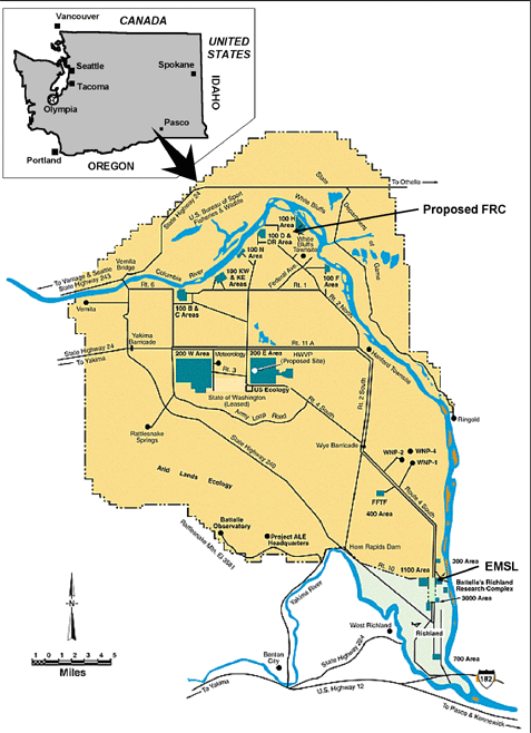
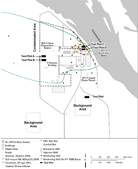
3.2 Pacific Northwest National Laboratory/Hanford Site 100-H AreaThe Hanford Site lies within the semiarid Pasco Basin of the Columbia Plateau in southeastern Washington State. The Hanford Site occupies an area of about 560 square miles (1,450 km2) north of the confluence of the Yakima River with the Columbia River. The Columbia River flows through the northern part of the site and turning south, forms part of the Hanford Site’s eastern boundary. Rattlesnake Mountain forms the southwestern boundary and the Saddle Mountains form the northern boundary. Adjoining lands to the west, north, and east are principally agricultural and range land. The cities of Richland, Kennewick, and Pasco (also referred to as the Tri-Cities) constitute the nearest population center and are located immediately to the southeast of the Hanford Site (Figure 3-8). In the late 1980s, portions of the Hanford Site were listed on the National Priorities List because of extensive contamination from past activities. In 1989, the DOE entered into an enforceable agreement with the U.S. Environmental Protection Agency and the State of Washington Department of Ecology for achieving environmental compliance. The Hanford Federal Facility Agreement and Consent Order, or Tri-Party Agreement, establishes enforceable milestones for achieving remediation and regulatory compliance. The Hanford Site encompasses more than 1,500 waste control units and four groundwater contamination plumes that have been grouped into 79 operable units. Each unit has complementary characteristics of such parameters as geography, waste content, type of facility, and relationship of contaminant plumes. The 79 operable units have been aggregated into four areas: 22 in the 100 Area, 43 in the 200 Area, five in the 300 Area, and four in the 1100 Area. The proposed FRC would be located in the 100-H Area. The 100-H Area was the site of one of nine plutonium production reactors, the H Reactor, which operated from 1949 to 1965. Following shutdown of reactor operations in the mid-1960s, most of the facility was demolished. The 100-H Area contains several CERCLA operable units that fall under the Tri-Party Agreement. The R-3 Operable Unit in the 100-H Area contains the contaminated groundwater underlying the 100-H Area. This designation is beneficial because although remediation-related activities within the operable unit must meet all of the substantive requirements of applicable permits, they do not need to obtain the permit itself. This operable unit is currently undergoing an interim remedial action (pump and treat system) for chromium contamination in accordance with a CERCLA Interim Record of Decision (ROD). The irregular boundaries of the proposed FRC site were chosen to avoid other construction and waste-remediation activities there, planned or ongoing. The contaminated area would encompass an area approximately 2,950 feet long by 2,300 feet wide (900 m by 700 m) (Figures 3-9 and 3-10). Two smaller background areas would be located just southeast and southwest of the contaminated area. As with the proposed ORNL background and contaminated areas, the proposed background and contaminated areas at the 100-H Area would have test plots of several areas (Figure 3-9). Groundwater extraction wells would be placed at the border of each test plot to capture groundwater that flows through the test plot area. In addition, monitoring wells would be placed outside the boundary of the FRC, particularly along the Columbia River, so that groundwater chemistry could be monitored.
Figure 3-8 Location of Proposed FRC in Hanford, Washington Back to the top
Figure 3-9 Proposed FRC in the 100-H Area of the Hanford site
Figure
3-10 Photographs of the Proposed FRC Contaminated 3.2.1 Earth Resources3.2.1.1 TopographyThe 100-H Area lies on an essentially low-relief, semiarid bench south of the Columbia River. The elevation of the area ranges from river level (~380 feet) to 425 feet above mean sea level. The land surface slopes gradually toward the river, with a bank up to 30 feet at the edge of the river. The surface topography of the 100-H Area reflects the impacts of river erosion (i.e., channeling) of the area during unregulated floods prior to construction of Priest Rapids Dam up-river. To the east, beyond the 100-H Area, lie the high-relief cliffs of eroded Ringold Formation, referred to as the White Bluffs. 3.2.1.2 GeologyThe Hanford Site is located near the junction of the Yakima Fold Belt and the Palouse structural subprovinces (DOE 1988a). The Palouse subprovince is primarily a regional paleoslope that dips gently toward the central Columbia Basin and exhibits only relatively mild structural deformation. The principal characteristics of the Yakima Fold Belt are a series of segmented, narrow, asymmetric anticlines. These anticlinal ridges are separated by broad synclines or basins that, in many cases, contain thick accumulations of sediments (i.e., Ringold and Hanford formations). Thrust or high-angle reverse faults are principally found along the limbs of the anticlines. . Figure
3-11 Stratigraphi c column for the Hanford site\
The 100-H Area lies within the Wahluke syncline, the east-west trending structural depression lying between Saddle Mountains to the north and the Umtanum Ridge-Gable Mountain uplift to the south. The Wahluke syncline is asymmetric and relatively flat-bottomed. The Umtanum Ridge-Gable Mountain uplift is a segmented, asymmetrical anticlinal ridge that extends onto the Hanford Site from the west. Gable Mountain and Gable Butte consist of two topographically isolated, anticlinal ridges composed of a series of northwest-trending, doubly plunging, en echelon anticlines, synclines, and associated faults. The potential for present-day faulting has been identified on Gable Mountain. Bedrock beneath the Hanford Site consists of the Miocene Columbia River Basalt Group (volcanic origin) interbedded with sedimentary deposits of the Ellensburg Formation. Overlying bedrock are suprabasalt sediments belonging to the Miocene-Pliocene Ringold Formation and Pleistocene Hanford formation. Other stratigraphic units of local extent include the early "Palouse" soil, the Plio-Pleistocene unit, and pre-Missoula gravels. The Hanford Site stratigraphy (Figure 3-11) is described in more detail in Neitzel et al. 1999. The Columbia River Basalt Group consists of continental flood basalts that erupted from linear vents within northeastern Oregon, eastern Washington, and western Idaho between 6 to 17 million years ago. The Saddle Mountains Basalt forms the uppermost basalt unit in the Pasco Basin, except along some of the bounding ridges where Wanapum and Grande Ronde Basalt flows are exposed. The fluvial-lacustrine Ringold Formation was deposited in generally east-west trending valleys by the ancestral Columbia River and its tributaries in response to development of the Yakima Fold Belt. Cataclysmic flooding, originating in western Montana and northern Idaho, spilled across eastern and central Washington, forming the channeled scablands and depositing sediments in the Pasco Basin. The last major flood occurred about 13,000 years ago. Cataclysmic floods inundated the Pasco Basin a number of times during the last ice age. The flood deposits, informally called the Hanford formation, blanket low-lying areas over most of the central Pasco Basin. Alluvium is present as a surficial deposit along the Columbia and Yakima Rivers; and in the subsurface, interbedded with cataclysmic flood deposits. Colluvium (talus and slopewash) is a common Holocene deposit in moderate- to-high-relief areas. Varying thicknesses of loess or sand mantle much of the Columbia Plateau. Active and stabilized sand dunes are widespread over the Pasco Basin. Landslide deposits in the Pasco Basin occur within the basalt outcrops along the ridges or steep river embankments (e.g., the north side of Rattlesnake Mountain and White Bluffs, respectively). Approximately 300 feet (91.5 m) of suprabasalt sediments overlie the proposed FRC and the 100-H Area. Sediments overlying Columbia River basalt include the Ringold Formation, the Hanford formation, as well as localized Holocene alluvium and backfill (Lindsey and Jaeger 1993). The Ringold Formation and Hanford formation are continuous across the 100-H Area. The Hanford formation consists primarily of gravel-dominated facies, with local occurrences of sand-dominated or silt-dominated facies. The Hanford formation generally thickens from north to south, ranging from 30 to 65 feet (9 to 20 m), and overlies fine-grained facies of the Ringold Formation. Ringold Formation sediments–with total thickness of 250 to 270 feet (76 to 82 m) near the proposed FRC –are dominated by lacustrine, overbank deposits and associated paleosols. All are represented within the 100-H Area. Fine-grained, overbank-paleosol facies (Ringold upper mud) (Auten and Myers 1996), comprises the upper 100 to 125 feet (30 to 38 m) of the Ringold Formation. The upper mud unit is described as a moderately consolidated, light brownish gray to light yellowish brown to reddish brown, sandy clayey silt to clayey silt (Fruchter et al. 1996). This unit averages 19.7 percent sand, 54.7 percent silt, and 25.5 percent clay. Two other Ringold units are present within the 100-H Area. A sandier facies (Unit B/D [Auten and Myers 1996]) separates the upper mud sequence from the Ringold lower mud unit. Unit B/D is composed of a fluvial sand facies. The Ringold lower mud unit (90- to100-foot total thickness) is interpreted to be lacustrine (Lindsey and Jaeger 1993). In the 100-H Area, an erosional unconformity exists between the Ringold and Hanford formations, which slopes gently toward the east. The upper contact with the Ringold Formation was scoured out during Pleistocene cataclysmic flooding, and subsequently deposited the Hanford formation during the waning stages of flooding (Baker et al. 1991). Seismicity of the Columbia Plateau is relatively low when compared with other regions of the Pacific Northwest, the Puget Sound area, and western Montana/eastern Idaho. The largest known earthquake in the Columbia Plateau occurred in 1936 near Milton-Freewater, Oregon. This earthquake had a Richter magnitude of 5.75. In the central portion of the Columbia Plateau, the largest recorded earthquake near the Hanford Site occurred in 1973. This event registered a magnitude of 4.4 and was located north of the Hanford Site near Othello. Earthquakes commonly occur in spatial and temporal clusters in the central Columbia Plateau and are termed "earthquake swarms." The region north and east of the Hanford Site is a region of concentrated earthquake swarm activity, but earthquake swarms have also occurred in several locations within the Hanford Site. The frequency of earthquakes in a swarm tends to gradually increase and decline without a large event in the sequence. Roughly 90 percent of the earthquakes in swarms have Richter magnitudes of 2 or less. These earthquake swarms generally occur at shallow depths, with 75 percent of the events located at depths of less than 2.5 miles (<4 km). Back to the top
3.2.1.3 Soils Hajek 1966 describes 15 different soil types on the Hanford Site, varying from sand to silty and sandy loam. In the 100-H Area, soils are classified as either Burbank loamy sand or Riverwash, with Riverwash occurring closer to the river. Burbank loamy soil is a course-textured soil underlain by gravel. The surface soil is usually about 16 inches (40 cm) thick, but can be 30 inches (75 cm) thick. This soil type is highly permeable. Soils beneath 100-H Area waste disposal sites have been found to contain uranium, technetium-99 (Tc99), strontium, and chromium, among other constituents.
3.2.2 Climate and Air Quality Climate at the Hanford Site is classified as mid-latitude semiarid or mid-latitude desert, depending on the climatological classification scheme used. Summers are warm and dry with abundant sunshine. Large diurnal temperature variations result from intense solar heating during the day and radiational cooling at night. Daytime temperatures in June, July, and August periodically exceed 100°F (38C). Winters are cool with occasional precipitation. Outbreaks of cold air associated with modified arctic air masses can reach the area and cause temperatures to drop below 0°F (-18C). Overcast skies and fog occur periodically. Air quality in the Hanford region is well within the state and federal standards for criteria pollutants, except that short-term particulate concentrations occasionally exceed the 24-hour "particulate matter nominally 10 microns or less" (PM10) standard. Benton County is in an "unclassified" area for PM10 (Neitzel et al. 1999). 3.2.3 Water Resources 3.2.3.1 Surface Water The primary surface water feature in the vicinity of the proposed FRC is the Columbia River. The primary uses of the Columbia River include the production of hydroelectric power and extensive irrigation in the Mid-Columbia Basin. Several communities located on the Columbia River rely on the river as their source of drinking water. The river is also used as a source of drinking water at several Hanford facilities and for onsite industrial uses (Neitzel et al. 1999). The Comprehensive Land Use Plan designates 43.1 miles (111.6 km) of the Columbia River adjacent to the Hanford Site as the Columbia River Corridor. Along the southern shoreline of the corridor, the 100 Areas occupy approximately 26 miles (68 km). RCRA closure permit restrictions have been placed in the vicinity of the 100-H Area, which is associated with the 183-H Solar Evaporation Basins. Additional deed restrictions or covenants for activities that potentially extend more than 15 feet (4.6 m) below ground surface are expected for CERCLA remediation areas. The Columbia River borders the 100-H Area on the northeast. The Hanford Reach is the only stretch of the Columbia River within the United States that is not impounded by a dam, though the flow is controlled by the Priest Rapids Dam located several miles upstream of the Hanford Site. The existence of the Hanford Site has precluded development of this section of the river for irrigation and power and the Hanford Reach is now currently under consideration for Wild and Scenic River status by the National Park Service. In 1988, Congress passed Public Law 100-605. The law requires the Secretary of Interior to prepare a study in consultation with the Secretary of Energy to evaluate the outstanding features of the Hanford Reach and its immediate environment and to institute interim protection measures. An Environmental Impact Statement (EIS) was prepared to evaluate the unique natural features of the Hanford Reach. Based on the evaluation in the EIS, the Secretary of Interior signed a Record of Decision on July 16, 1996 (DOI 1996), recommending Congress designate the Hanford Reach and public land within one-quarter mile of the river on the south shore (as well as a larger area on the north shore) as a Wild and Scenic River. To date, despite the introduction of bills concerning this issue, Congress has not acted to designate the Hanford Reach as a Wild and Scenic River. Water samples are collected quarterly from the Columbia River along established points on the Hanford Site as well as immediately upstream and downstream. The current major source of heat to the Hanford Reach is solar radiation. The average pH values ranged from 7.7 to 8.1. Mean specific conductance values ranged from 128 to 165 microSiemens/cm. Radionuclides consistently detected in the river during 1998 included tritium, Sr-90, I-129, U-234,238, and Pu-239,240. Total alpha and beta measurements (useful indicators of the general radiological quality that provide an early indication of changes in radioactive contamination levels) were approximately 5 percent or less of the applicable drinking water standards of 15 and 50 pCi/L, respectively (Neitzel et al. 1999, PNNL 1998).
3.2.3.2 Floodplain and Wetlands There are no Federal Emergency Management Agency (FEMA) floodplain maps of the Hanford Reach of the Columbia River. Prior to 1933, when the Columbia River was free-flowing, periodic large floods occurred that affected the 100-H Area. This is indicated by a series of fluvial channels that dissect older cataclysmic-flood and older fluvial deposits in the vicinity of 100-H Area. These channels were probably last occupied during the largest known unregulated historical flood, which occurred in 1894 and is estimated to have a discharge of 742,000 cubic feet per second (21,000 cubic meters per second [m3/s]) (Neitzel et al. 1999). The Columbia River flow is now controlled by a series of dams located both upstream and downstream of the Hanford Area. The largest recent flood at the Hanford Area took place in 1948 with an observed peak discharge of 700,000 cubic feet per second (20,000 m3/s). The 1948 flood did not inundate the 100-H Area. An estimate of the 100-year dam-regulated flood is 440,000 cubic feet per second (12,400 m3/s) (Neitzel et al. 1999). The 100-year regulated flood would not affect the 100-H Area. The 100-H Area does not include any wetlands other than the narrow ribbon of wetlands along the shoreline of the Columbia River; these wetlands are not located within the proposed FRC (Neitzel et al. 1999).
3.2.3.3 Groundwater Groundwater beneath the Hanford Site is found in both an upper unconfined aquifer system and deeper basalt-confined aquifers (Neitzel et al. 1999). Portions of the upper aquifer system are in locally confined or semiconfined. Confined aquifers within the Columbia River Basalt Group are formed by relatively permeable sedimentary interbeds and the more porous tops and bottoms of basalt flows. The horizontal hydraulic conductivities of most of these aquifers fall in the range of 3 x 10⁻¹⁰ to 3 x 10⁻⁴ feet per second (10-10 to 10-4 m/s). The dense interior sections of the basalt flows have horizontal hydraulic conductivities ranging from 3 x 10-15 to 3 x 10⁻⁹ feet per second (10-15 to 10-9 m/s), about five orders of magnitude lower than those of the confined aquifers. Groundwater in the basalt confined aquifers generally flows toward the Columbia River and, in some places, toward areas of enhanced vertical communication with the unconfined aquifer system. Groundwater in the unconfined aquifer at Hanford generally flows from recharge areas in the elevated region near the western boundary of the Hanford Site toward the Columbia River on the eastern and northern boundaries (the 100-H Area). The Columbia River is the primary discharge area for the unconfined aquifer. Along the Columbia River shoreline, daily river level fluctuations may result in water table elevation changes of up to 10 feet (3 m). During the high river stage periods of 1996 and 1997 some wells near the Columbia River showed water level changes of more than 10 feet). As the river stage rises, a pressure wave is transmitted inland through the groundwater. The longer the duration of the higher river stage, the farther inland the effect is propagated. The pressure wave is observed farther inland than the water actually moves. For the river water to flow inland, the river level must be higher than the groundwater surface and must remain high long enough for the water to flow through the sediments. Typically, this inland flow of river water is restricted to within several hundred feet of the shoreline. Groundwater recharge from precipitation across the entire Hanford Site is thought to range from approximately 0 to 4 inches per year (0 to 10 cm/yr) but is probably less than 1 inch per year (<2.5 cm/yr) over most of the Site. Since 1944, the artificial recharge from Hanford wastewater disposal in the 200 Areas has been significantly greater than the natural recharge. An estimated 4.44 x 10¹¹ gallons (1.68 x 10¹² L) of liquid was discharged to disposal ponds, trenches, and cribs from 1944 to the present. Horizontal hydraulic conductivities of sand and gravel facies within the Ringold Formation generally range from about 0.9 to 9 feet per day (0.3 to 3 meters per day [m/d]) compared to 1,000 to 10,000 feet per day (300 to 3,000 m/d) for the Hanford formation. Because the Ringold sediments are more consolidated and partially cemented, they are approximately 10 to 100 times less permeable than the sediments of the overlying Hanford formation. Before wastewater disposal operations at the Hanford Site, the uppermost aquifer was mainly within the Ringold Formation and the water table extended into the Hanford formation at only a few locations. However, wastewater discharges raised the water table elevation across the Site, especially within the 200 Areas. Because of the general increase in groundwater elevation, the unconfined aquifer now extends upward into the Hanford formation. This change has resulted in an increase in groundwater velocity not only because of the greater volume of groundwater but also because the newly saturated Hanford sediments are highly permeable. More recently, water levels have declined over most of the Hanford Site because of decreased wastewater discharges (Neitzel 1999). The hydrology of the 100 Areas is notable because of the location adjacent to the Columbia River. A map showing the water table elevations in the vicinity of the 100-H Area is shown in Figure 3-12. The water table ranges in depth from near 0 feet at the river edge to 107 feet (30 m). The groundwater flow direction is generally toward the river. During high-river stage, however, the flow direction may reverse immediately adjacent to the river. The groundwater gradient varies depending on the distance from the river and the time of year. Groundwater flow near the river is strongly influenced by fluctuations in Columbia River stage, which is controlled by dams. River stage can vary 6 to 8 feet daily and 8 to 10 feet seasonally. The hydraulic gradient is greatly increased near the river during periods of low flow. As the river stage increases the gradient flattens, as the groundwater responds to a higher discharge elevation. Normal peak discharge occurs during June while normal low flow occurs in October and November. River stage can influence wells up to 2,000 feet (600 m) inland from the river. Confined aquifer layers have potentiometric surfaces that are generally above those of the unconfined aquifer. Groundwater Quality Groundwater quality has been negatively impacted by past practices at the 100-H Area, and because of its proximity to the Columbia River, the 100-H Area has received high priority for the remediation of hazardous and radioactive wastes at Hanford. Contaminants of concern include chromium, nitrate, Tc99, and uranium, all of which occur above drinking water standards within the 100-H Area. A pump and treat system is presently in operation to contain these contaminants and prevent them from entering the river. The proposed FRC is located hydraulically upgradient of the pump and treat system. The system is presently pumping contaminated groundwater from five wells immediately adjacent to the river, passing the water through an ion-exchange filter and injecting the treated water into several wells located 1,970 to 2,300 feet (600 to 700 m) upgradient of the river. Through the CERCLA Interim Record of Decision, the EPA and DOE are scheduled to review the status and success of this pump and treat effort in 2002. At that time, changes might be made to the pump and treat system.
Figure 3-12 Groundwater table in the vicinity of the 100-H Area
3.2.4 Ecological Resources The following section identifies and describes the terrestrial, and aquatic resources that occur on the Hanford Site and in the 100-H Area 3.2.4.1 Terrestrial Resources The Hanford Site is located within what has been botanically characterized as a shrub-steppe ecosystem, with various shrub and bunchgrass associations playing dominant roles. The region is often referred to as high desert, northern desert shrub, or desert scrub (Franklin and Dyrness 1973). The Hanford Site is a relatively large, undisturbed area of shrub-steppe habitat that contains numerous plant and animal species adapted to the semi-arid environment in the region. The major DOE facilities and infrastructure occupy only a small part of the site and their impact on the surrounding ecosystems is minimal. Most of the Hanford Site has not experienced tillage or livestock grazing since the early 1940s. A pedestrian and visual reconnaissance of the proposed contaminated area and the background area near the southeast corner of 100-H Area was performed by staff from the Hanford Biological Resources Laboratory on April 23, 1998. An additional background area, which is proposed to be to the south/ southwest of the original 100-H perimeter, has not been recently surveyed. However, information on the habitat of the region was obtained from the habitat classification database of the Ecosystems Monitoring Project (Neitzel et al. 1999). The Braun-Blanquet cover-abundance scale (Bonham 1989) was used to determine percent cover of dominant vegetation. The northern portion of the proposed contaminated area is characterized as a Rabbitbrush (Crysothamnus nauseosus)/cheatgrass (Bromus tectorum) community, with a significant amount of bulbous bluegrass (Poa bulbosa). Other portions of the proposed contaminated area are primarily characterized as cheatgrass communities. All proposed contaminated areas have been previously disturbed. The proposed background area in the southeast corner of 100-H Area is characterized as a cheatgrass community. In 1999, the U.S. Fish and Wildlife Service provided a list of threatened and endangered species, candidate species and species of concern, which may be present in the Benton County portion of the Hanford Area (Appendix E). However, no plant or animal species protected under the Endangered Species Act, candidates for such protection, or species listed by the Washington State government as threatened or endangered were observed within the proposed FRC boundaries. Bald eagles use the river area adjacent to the proposed area during the winter. Bald eagles are currently on the Federal Endangered Species list; however, a proposal to delist the bald eagle was published in the Federal Register, July 6, 1999. A final decision is expected in July 2000. 3.2.4.2 Aquatic Resources The Columbia River is the dominant aquatic ecosystem on the Hanford Area and flows to the northeast of the 100-H area. The river supports a large and diverse community of fish, benthic invertebrates, and other communities. Neitzel 1999 lists 43 species of fish in the Hanford Reach of the Columbia River. The brown bullhead (Ictalurus nebulosus) has been collected since 1977, bringing the total number of fish species identified in the Hanford Reach to 44. Of these species, chinook salmon, sockeye salmon coho salmon, and steelhead trout use the river as a migration route to and from upstream spawning areas and are of the greatest economic importance. The Upper Columbia River steelhead, Upper Columbia River spring-run chinook salmon, and the bull trout are known to occur in the Columbia River immediately adjacent to the proposed project areas. All three species are federally listed as endangered Benthic organisms are found either attached to or closely associated with the substratum. All major freshwater benthic taxa are represented in the Columbia River. Insect larvae such as caddisflies (Trichoptera), midge flies (Chironomidae), and black flies (Simuliidae) are dominant. Other benthic organisms include limpets, snails, sponges, and crayfish. Peak larval insect densities are found in late fall and winter, and the major emergence is in spring and summer (Neitzel 1999). 3.2.5 Archaeological, Cultural, and Historic Resources Management of the Hanford Area cultural resources follows the Hanford Cultural Resources Management Plan (PNL 1989), which was approved by the State Historic Preservation Office in 1989. The Management Plan was developed to establish guidance for the identification, evaluation, recordation, curation, and management of archaeological, historic, and traditional cultural resources as individual entities or as contributing properties within a district. The plan specifies methods of consultation with affected tribes, government agencies, and interested parties, and includes strategies for the preservation and/or curation of representative properties, archives, and objects. The proposed contaminated area was reviewed by staff from the Hanford Cultural Resources Laboratory (Appendix E). There are no known historic properties within the proposed contaminated area. A records review indicated that approximately half of the proposed contaminated area has been intensively surveyed for cultural resources. No archaeological sites or isolated artifacts were identified in the survey area. The proposed contaminated area is primarily within areas where the ground surface has been disturbed by prior Hanford Site construction activities. All but a very small part of the remainder of the proposed contaminated area not intensively surveyed is identified as original ground surface. Part of the proposed contaminated area is within 1,310 feet (400 m) of the Columbia River, which is considered culturally sensitive. A cultural resource expert is required to be present during excavation in this area. The proposed southwest and southeast background areas have also been previously surveyed for cultural resources. No archaeological sites or isolated artifacts were located within the background areas. Review of 1941 aerial photographs indicates that, prior to Hanford Site development, the southwest background area was undeveloped range land, while the southeast background area was a combination of undeveloped and agricultural land. There are no known historic properties within either of the background areas. 3.2.6 Land Use, Recreation, and Aesthetic Resources The Hanford Site encompasses 560 square miles (1,450 km2) and includes several DOE operational areas. Land use categories at the Hanford Site include reactor operations, waste operations, administrative support, operations support, sensitive areas, and undeveloped areas. Remedial activities are currently focused within or near the disturbed areas, such as the 100 Areas. Much of the Hanford Site is undeveloped, providing a safety and security buffer for the smaller areas used for operations. The entire Hanford Site has been designated a National Environmental Research Park. Public access to most facility areas is restricted. DOE, in partnership with several cooperating agencies, has issued a Record of Decision based on the Hanford Comprehensive Land-Use Plan Environmental Impact Statement (EIS) (DOE/RL 1999b) to address proposed land uses at the Hanford Site over the next 50 years. The comprehensive land use plan provides a comprehensive and long-term approach to planning and development for the Hanford Site and recognizes the multiple uses that must be coordinated, including research and development activities. The 100 Areas are the site of eight retired plutonium production reactors and the N Reactor. The facilities in the 100 Areas are being placed in a stabilized state for ultimate decommissioning. Remedial activities are currently focused within or near the disturbed areas. Access to the Hanford Site is restricted, so recreation does not occur on the site. However, access to the Hanford Reach of the Columbia River, which flows adjacent to the 100-H Area, is unrestricted. The river is used extensively for fishing, hunting, boating, windsurfing, water-skiing, diving, and swimming. The Hanford Reach of the Columbia River is designated as Class A, Excellent. Class A waters are suitable for all uses, including raw drinking water, recreation, and wildlife habitat. Water quality is routinely monitored from locations upstream and downstream of the Hanford Site. State and federal drinking water standards apply to the Columbia River and are currently being met. The land in the vicinity of the Hanford Site is generally flat with little relief. Rattlesnake Mountain, rising to 3,480 feet (1,060 m) above mean sea level, forms the southeastern boundary of the Hanford Site. Gable Mountain and Gable Butte are the highest landforms within the Hanford Site. Large rolling hills are located to the west and north of the Site. The Columbia River, flowing across the northern part of the Site and forming the eastern boundary, is generally considered scenic, with its contrasting blue against a background of dark basaltic rocks and desert sagebrush. The White Bluffs’ steep, whitish-brown bluffs adjacent to the Columbia River (located across the river from the 100-H Area) are a striking natural feature of the landscape. 3.2.7 Socioeconomic Conditions The Tri-Cities constitute the nearest population center and are located southeast of the Hanford Site. The 1997 estimates distributed the Tri-Cities population as follows: Richland 36,860, Pasco 26,000, and Kennewick 50,390. Activity on the Hanford Site plays a dominant role in the socioeconomics of the Tri-Cities and surrounding counties. In addition to providing direct employment, the Hanford payroll has a widespread impact on the Tri-Cities and state economies (Neitzel et al. 1999). Three major employment sectors have been the principal driving forces of the economy of the Tri-Cities since the early 1970s: 1) DOE and its contractors operating the Hanford Site; 2) Energy Northwest and its operation of a commercial nuclear power plant located on the Hanford Site; and 3) the agricultural community, including a substantial food processing component. In 1997, nearly 20 percent of the nonagricultural jobs in Benton and Franklin counties were composed of DOE and its contractors at the Hanford Site (Neitzel et al. 1999). Land in the surrounding environs is used for urban and industrial development, irrigated and dry-land farming, and grazing. Major industrial facilities within a 50-mile (80-km) radius include a meat-packing plant, food-processing facilities, fertilizer plants, a pulp and paper mill, chemical plant, hydroelectric dams, and small manufacturing firms. Within a 50-mile radius of the 100-H Area, but outside the Hanford boundary, agriculture is the predominant land use. Government facilities located on the Hanford Site include retired chemical processing plants, radioactive waste control units, decontamination facilities, nuclear materials storage facilities, research laboratories, and a retired reactor at the 100-H Area. Commercial use of the Hanford Site includes a nuclear power plant (Energy Northwest Nuclear Plant 2) and a low-level radioactive waste burial area administered by Washington State and operated by U.S. Ecology Inc. 3.2.8 Human Health Radioactive emissions from many onsite facilities are approaching levels practically indistinguishable from the naturally occurring radioactivity present everywhere. (PNNL 1998). This translates to a very small offsite radiation dose attributable to site activities. Using thermoluminescent dosimeters, radiological dose rates were measured at both onsite and offsite locations during 1997. Radioactive substances contributing to the measured dose rates were of either natural or man-made origin. The dose rates did not change significantly from the dose rates measured in previous years. The 1997 annual average background dose rate measured in communities distant from the Hanford Site was 67 ± 1 millirem per year (mrem/yr). The 1997 annual average perimeter dose rate was 89 ± 10 mrem/yr. All onsite thermoluminescent dosimeters averaged 85 ± 5 mrem/year (PNNL 1998). The Hanford Environmental Health Foundation (HEHF) provides occupational health services to Hanford personnel through health risk management and occupational health monitoring. The HEHF’s health risk management program identifies and analyzes the hazards Hanford personnel face in the work environment and brings an awareness to worker heath and safety issues at Hanford. HEHF’s occupational health services provide occupational medicine and nursing, including medical monitoring and surveillance; ergonomics assessment; psychology and counseling; fitness for duty evaluation; infection control; immediate health care; industrial hygiene; and health, safety, and risk assessments. Noise Background noise levels were evaluated in the 1980s at five Hanford Site locations. Noise levels were expressed as equivalent sound levels for 24 hours (Leq-24). The average noise level for these five sites was 38.8 dB/A on the dates tested. The wind was identified as the primary contributor to background noise levels, with winds exceeding 12 miles per hour (19 km/hr) significantly affecting noise levels. This study concluded that background noise levels in undeveloped areas at the Hanford Site are generally in the range of 24 to 36 dB/A. Periods of high wind, which normally occur in the spring, would elevate background noise levels (Neitzel et al. 1999). Noise levels at the 100-H Area are expected to be similar to the levels identified in the Hanford study. There might occasionally be higher noise levels associated with ongoing remediation work at 100-H. Potential activities at the contaminated area and background area are listed in Section 2.2.3. Noise associated with potential FRC activities would be produced by well-drilling equipment, compressors, trucks, and generators. Noise from FRC activities would be temporary and likely to disturb wildlife or other sensitive receptors for only short periods during daylight hours. 3.2.9 Waste Control Wastes generated at the proposed contaminated area and background area could include small quantities of contaminated groundwater from drilling wells and sampling in contaminated zones; small quantities of excess soil from coring; field laboratory wastes, some of which would be considered RCRA waste; biological wastes; domestic wastes from the offices and laboratories; and sanitary wastes. There are existing waste disposal facilities on the Hanford Site for the disposal of radioactive, hazardous, chemical, biological, and domestic wastes.
3.2.10 Transportation U.S. Department of Transportation (DOT) Hazardous Materials Regulations (Title 49, CFR, Parts 171-180) establishes requirements governing packaging and shipping hazardous materials on public highways. The standards are applicable to any necessary shipments of hazardous materials to or from the proposed FRC. The PNNL Shipping and Transportation Program ensures compliance with the DOT Hazardous Materials Regulations and DOE requirements specific to packaging and transportation safety. The PNNL Hazardous Materials Transportation Officer would be consulted to assure safe packaging and transportation of regulated samples, hazardous materials, or wastes. The 100-H Area is restricted to use only by DOE and its contractors. In the vicinity of the proposed FRC, the majority of roads are being used for the decommissioning of the H Reactor Building, and for remediation activities at the 183-H Solar Evaporation Basins and 107-H Liquid Waste Trench. Large trucks are frequently on the roads. 3.2.11 Utilities and Services The Hanford Site has a potable and raw water system, supplying the developed areas of the Site, including the 100-H Area. Electrical power is provided to the 100 Areas from the Bonneville Power Administration. Additional support services include sewers, fire protection, waste disposal, and safeguards, and security. Key elements of site infrastructure include facilities and roads (DOE/RL 1994a). Onsite programmatic and general purpose facilities provide 6.5 million square feet (600,000 m2) of space. General purpose facilities include offices, laboratories, shops, warehouses, and other facilities. Programmatic space supports a liquid waste evaporator, waste recovery, treatment, storage facilities, and research and development laboratories. The road network is well developed at Hanford with approximately 290 miles (460 km) of roads. Upgrades are planned or underway to support remediation efforts including in the 100 Areas, as hauling wastes and waste site cover material is integral to many of the remediation efforts. Ancillary facilities would be used to support the proposed FRC. FRC staff and researchers would use existing facilities at PNNL, including offices/laboratories in the Life Science Building (331 Building), the Environmental Molecular Sciences Laboratory, Sigma V Building, the Research Technology Laboratory, the Chemical Engineering Laboratory, and the Plant Growth Facilities. 3.2.12 Environmental Justice On February 11, 1994, the President of the United States issued Executive Order 12898, Federal Actions to Address Environmental Justice in Minority Populations and Low-Income Populations. The Executive Order mandates that each federal agency make environmental justice part of the agency mission and to address, as appropriate, disproportionately high and adverse human health or environmental effects of the programs and policies on minority and low-income populations. Approximately 383,934 people live within a 50-mile (80-km) radius of the Hanford Site. Based on 1990 census data, minorities compose nearly 25 percent of the population. The distribution of minority populations residing in areas surrounding the Hanford Site is shown in Table 3-2. The table shows minority populations and the racial and ethnic compositions within a 50-mi (80-km) radius of the Site. At the time of 1990 census, Hispanics composed nearly 81 percent of the minority population surrounding the Hanford Site. The Site is also surrounded by a relatively large percentage (about 8 percent) of Native Americans because of the presence of the Yakama Indian Reservation in the vicinity (Neitzel et al. 1999). Table 3-2. Description of the Populations Surrounding the Hanford Site (1990)
3.3 No Action There would be no affected environment under the No Action alternative. No DOE sites would be used for operation of an FRC to conduct basic fundamental bioremediation research.
| ||||||||||||||||||||||||||||||||||||||||||||||||||||||||||||||||||||||||||||||||