This section describes the affected environment of the three alternatives for the proposed action–the ORNL/Y-12 Site, the PNNL/Hanford 100-H Area, and No Action. Each description includes the site location and a summary of the existing environmental conditions on and in the vicinity of the site. Included in this section are descriptions of the existing earth resources; climate and air quality; water resources; ecological resources; archaeological, cultural and historical resources; land use; recreation and visual/aesthetic resources; socioeconomic conditions; waste control; human health; and environmental justice. 3.1 Oak Ridge National Laboratory/Y-12 SiteA proposed host site for the FRC would be the DOE Oak Ridge Reservation (ORR) in East Tennessee. The ORR consists of approximately 34,516 acres (13,968 hectare [ha]) of land and is the site for three major DOE facilities–the Oak Ridge National Laboratory (ORNL), the Y-12 Plant, and the East Tennessee Technology Park (ETTP), formerly known as the K-25 Site. Figure 3-1 shows the general location of the ORR, surrounding counties, and the location of the three major DOE facilities within the Oak Ridge and Knoxville region. The majority of the ORR falls within the corporate limits of the city of Oak Ridge in Anderson and Roane counties. The Clinch River borders the ORR to the east, south and west, while the residential and commercial portions of the city of Oak Ridge are located to the north of the ORR. The ORR was placed on the Comprehensive Environmental Response, Compensation and Liability Act (CERCLA) National Priorities List in 1989. Remediation efforts at ORR, including individual sites in Bear Creek Valley, are governed by the Federal Facility Agreement (FFA) among DOE, Region IV of the U.S. EPA, and the Tennessee Department of Environment and Conservation (TDEC). Subsequently, the Remedial Investigation/Feasibility Study (RI/FS) for the Bear Creek Watershed has been completed to address contamination associated with former waste disposal activities in Bear Creek Valley. The Record of Decision (ROD) is scheduled to be signed in calendar year 2000. Several CERCLA remedial actions have been identified for implementation in the Bear Creek Valley Watershed. Proposed CERCLA actions that could impact levels of groundwater and soil contamination within the proposed FRC boundaries include but are not limited to the following: hot spot removal and capping of the BY/BY, S-3 Ponds plume tributary interception, and removal of soil and sediment hot spots of contamination within the Bear Creek floodplain. The proposed FRC contaminated area and background area lie within the Y-12 Plant area of responsibility on the ORR. The Y-12 area of responsibility, including the area located outside the Y-12 perimeter security fence, includes 4,468 acres (1,808 ha). The Y-12 Plant is located in Bear Creek Valley (BCV) adjacent to the city of Oak Ridge. The developed portion of the plant covers an area of 811 acres (328 ha), with some 250 buildings that house about 7 million square feet of laboratory, machining, dismantlement, and research and development areas. The Y-12 Plant is operated by Lockheed Martin Energy Systems, the Management and Operations contractor. Bechtel Jacobs Company, Limited Liability Corporation (BJC) is the Management and Integration contractor responsible for environmental management activities. The proposed FRC would include a 243-acre (98-ha) previously disturbed contaminated area and a 404-acre (163-ha) background area (Figure 3-1). The contaminated area would be used for conducting experiments on contaminated groundwater and subsurface sediments. The background area would provide for comparison studies in an uncontaminated area. Initially, test plots of approximately one-half acre, situated in proximity to the S-3 Ponds Site parking lot (Figure 3-2 and Figure 3-3) would be used. As the course of NABIR investigations proceed, other test plots might be used farther down BCV. The proposed contaminated area and background area would be located in BCV (Figure 3-2 and Figure 3-3). BCV is approximately 10 miles (16 kilometers [km]) long and extends from the eastern end of the Oak Ridge Y-12 Plant to the Clinch River on the west (Figure 3-1). Bear Creek is a tributary to East Fork Poplar Creek, which drains into the Clinch River at ETTP. Except for the extreme eastern end of the contaminated part of the proposed FRC, the area is outside of any security fences, adjacent to public use roads, but protected from unwarranted passersby. Back to the top3.1.1 Earth Resources3.1.1.1 TopographyThe ORR lies within the Valley and Ridge Physiographic Province, which is characterized by steep-sided parallel ridges with broad intervening valleys, generally oriented in a northeast-southwest direction. The valleys are generally underlain by softer rocks that are not as resistant to erosion as the rocks beneath the ridges. BCV is bordered by Pine Ridge on the northwest and by Chestnut Ridge on the southeast. Topographic relief from the crest of Pine Ridge to the floor of BCV ranges from 260 to 300 feet (79 to 91 meters [m]); relief from the crest of Chestnut Ridge to the floor of BCV ranges from 280 to 400 feet (85 to 122 m). The average elevation of the ridges is approximately 1,100 feet (335 m) above mean sea level (amsl), with elevation of the floor of BCV ranging from 800 feet (244 m) to 1,000 feet (305 m) amsl. Back to the top3.1.1.2 GeologyThe western Appalachian Valley and Ridge Province is characterized by northwestward-moving, southeast-dipping imbricate thrust sheets. The Copper Creek and White Oak Mountain fault thrust sheets are traceable through the ORR. Bear Creek Valley is part of the White Oak Mountain fault thrust sheet. The geological units in the ORR (Hatcher et al. 1992) can be grouped into low permeability shales and higher permeability carbonates (Solomon et al. 1992). On a regional scale, the geology of Bear Creek Valley is limestone- and dolomite-dominated (carbonate) rock groups interbedded with predominantly clastic shale groups. On an outcrop scale, clastic shale beds are interlayered with carbonate beds. The geologic units are parallel to the valleys and ridges. Bear Creek Valley is underlain by the Rome Formation, the Conasauga Group, and the Knox Group (Figure 3-4). All of these rocks were formed over 500 million years ago. The Rome Formation and the Co nasauga Group crop out in BCV on Pine Ridge and dip to the southeast beneath BCV. 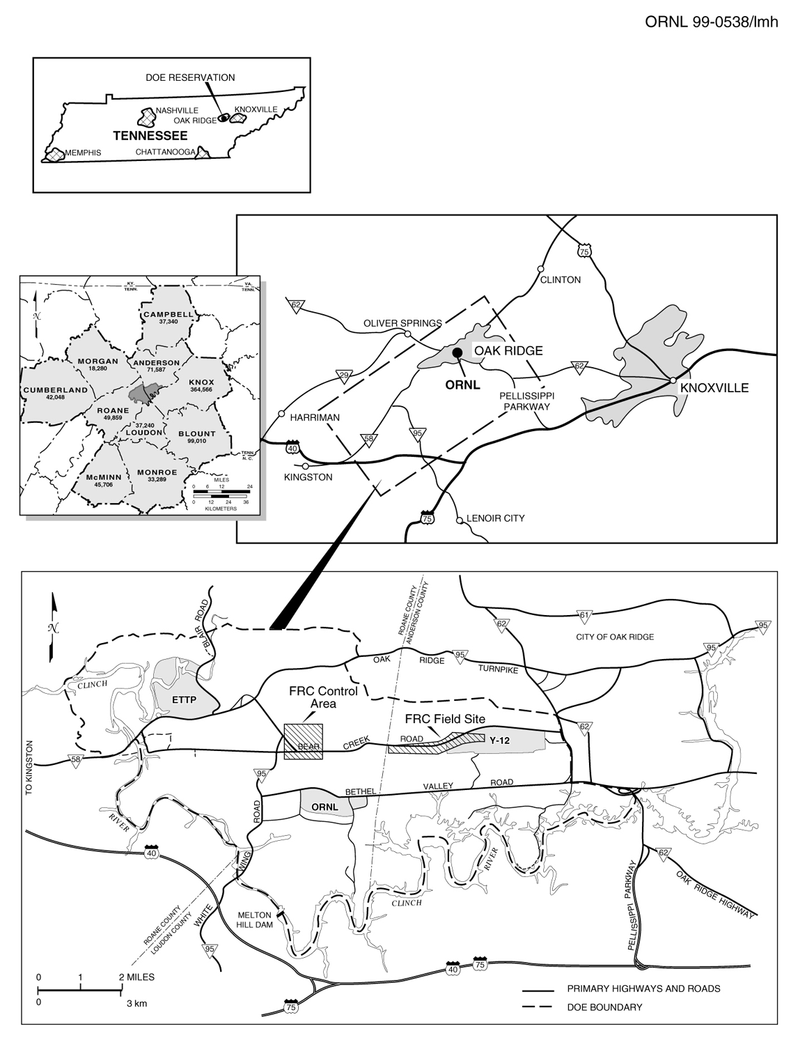 Figure 3-1 Location of Proposed FRC in Oak Ridge, Tennessee 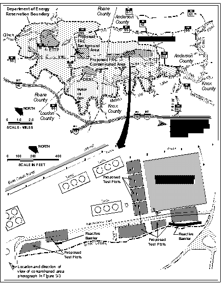
Figure
3-2 Location of the Background Area, and the initial test plots
Figure
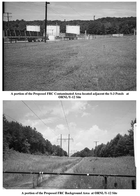
3-3 Photographs of the Proposed FRC Contaminated
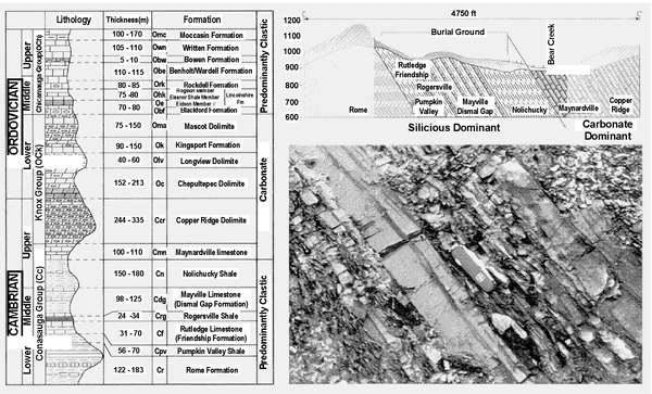
Figure 3-4 Geology of the proposed FRC
With the exception of the Maynardville Limestone, the Conasauga Group is a sequence of fractured shale, siltstone, and thin-bedded limestone. Some formations include laterally continuous limestone beds. High permeability zones parallel to bedding planes may exist, especially where karstification has enlarged fractures. The Knox Group (i.e., Copper Ridge Dolomite) underlies and forms Chestnut Ridge, the southern boundary of BCV. It is composed of a series of medium- to thick-bedded, massive dolomite. Fracturing and karst formation in the Knox Group have resulted in locally high permeability (Shevenell and Beauchamp 1994). Sinkholes are common, and springs and seeps are common features at the upper and lower geologic contacts. The primary geologic units that underlie the proposed contaminated area and background area are the Maynardville Limestone (carbonate) and Nolichucky Shale. The Maynardville Limestone, which forms the BCV floor, is a massively bedded limestone and dolomite (carbonate) with fracturing and karstification. The Nolichucky Shale is located just up slope and stratigraphically lower than the Maynardville Limestone. There may be some geologic hazard associated with rare occurrence of sinkhole development in carbonate rock units in BCV. Hazards related to seismic activity along the faults located in the East Tennessee Valley and Ridge geologic province are relatively minor. There has been no known recent fault activity, although numerous small earthquakes (Richter magnitude of less than 4) occur yearly. Back to the top
3.1.1.3 Soils and Waste Areas Overlying the bedrock on the ORR is unconsolidated material that consists of weathered bedrock (referred to as residuum), man-made fill, alluvium, and colluvium. Silty and clayey residuum comprises a majority of the unconsolidated material in this area. The depths to unweathered bedrock differ throughout the ORR because of the different thicknesses of fill and alluvium and the particular weathering characteristics of the bedrock units. The total thickness of these materials typically ranges from 10 to 50 feet (3 to 15 m) (Hoos and Bailey 1986). The principal waste areas and contaminant sources in BCV– the S-3 Ponds Site, the Oil Landfarm and Boneyard/Burnyard (BY/BY) area, and the Bear Creek Burial Grounds (BCBG)–are located in the upper 2.2 miles (3.5 km) of the valley on the outcrop of the Nolichucky Shale. Solid and liquid waste disposal has caused shallow soil and groundwater contamination. Where dense liquids were disposed of at the S-3 Ponds Site and BCBG, contamination of shallow and deep groundwater in the Nolichucky Shale has occurred. The following volumes of waste and contaminated soils are estimated to be present in BCV (note that volume estimates for soils and wastes do not include the volumes of the caps themselves):
In addition,
it is estimated tha
3.1.2 Climate and Air Quality The climate of the region surrounding the Oak Ridge area is broadly classified as humid continental. The Cumberland Mountains to the northwest have a moderating influence on the climate of the area by shielding the region from cold air masses that frequently extend far south over the plains and prairies of the central United States during the winter months. In the summer months, tropical air masses from the south provide warm and humid conditions that often produce thunderstorms; however, anticyclonic circulation around high-pressure systems centered in the western Gulf of Mexico can bring dry air from the southwestern United States into the region, which causes occasional periods of drought. The annual mean air temperature for the Oak Ridge area is 57.1°F (13.9°C) (1963 through 1992 base period). The coldest month is usually January, with temperatures averaging about 35.6°F (2.0°C), but occasionally falling as low as -17°F (-27°C). July is typically the hottest month of the year, with average temperatures of 76.5°F (24.7°C), but occasionally rising to 105°F (41°C). Diurnal temperature changes are relatively consistent from month to month having a range of 18 to 27°F (10 to 15°C). Average precipitation in the Oak Ridge area varies from place to place by as much as 30 percent depending on the location relative to local terrain. The 40-year annual average precipitation is 53.75 inches (137 centimeters [cm]), including about 10.4 inches (26 cm) of snowfall. Precipitation in the region is greatest in the winter and spring months (January through April) and least during the fall months (September through November), when high-pressure systems are most frequent. The Oak Ridge area has relatively light winds compared to other parts of the United States. The Cumberland Mountains and Plateau to the northwest and west, and the local valley-and-ridge topography divert severe storms and minimize air movement and local wind impact. Ridge-top and valley sites in the Oak Ridge area (excluding the Cumberland Plateau) experience wind speeds less than 11.2 miles per hour (5 meters per second [m/s]) over 90 percent of the time, and many valley-bottom sites experience winds less than 4.5 miles per hour (2 m/s) over 70 percent of the time. Prevailing wind directions in the Oak Ridge area are primarily oriented parallel to the direction of the local ridge and valley terrain. Prevailing winds are either up-valley (northeasterly) day-time winds, or down-valley (southwesterly) night-time winds. Existing air quality at ORR is in attainment with National Ambient Air Quality Standards (NAAQS) for all criteria pollutants (i.e., sulfur dioxide, nitrogen dioxide, inhalable particulate matter, carbon monoxide, ozone, and lead). The Y-12 Site has permits for radiological and non-radiological air emissions. Radioactive emissions are registered by EPA under NESHAP regulations (40 CFR 61, Subpart H). Non-radiological emissions are regulated under the rules of Tennessee Department of Air Pollution Control (ORNL 1998). 3.1.3 Water Resources 3.1.3.1 Surface Water Bear Creek is the predominant surface water feature of the proposed FRC in BCV. The creek is one of the surface water features of the ORR, which is characterized by a network of small streams that are tributary to the Clinch River. Water levels in the Clinch River are regulated by the Tennessee Valley Authority (TVA), and fluctuations in the river have a localized effect on tributary creeks and streams draining the ORR. Drainage from Y-12 enters both Bear Creek and East Fork Poplar Creek (EFPC); the headwaters of both originate within the Y-12 Area. Bear Creek and EFPC have total drainage areas of 7.4 and 30 square miles (1,900 and 7,700 ha), respectively. Bear Creek is a relatively small (third-order) spring-fed stream that flows out of the Y-12 Plant and ultimately into the EFPC. Its watershed divide with EFPC crosses the western portion of the plant site near the S-3 Ponds Site, and most of the drainage from the Y-12 facilities flows to the EFPC. In addition to EFPC and Bear Creek, there are numerous streams, springs, and quarries/ponds within the Y-12 Area. Bear Creek flows west down BCV and then flows north where it empties into EFPC. Little high-density development has occurred within the Bear Creek watershed, but a great deal of clearing and waste control activity has taken place. The drainage pattern of Bear Creek is a good example of trellis (i.e., lattice-like) drainage patterns typical of the Valley and Ridge Province. About 65 percent of the drainage basin is wooded. Although Bear Creek does not drain the main Y-12 site, it does drain the areas used for waste storage and closed waste disposal areas. As mentioned in Section 3.1.1.3, contaminants originating from the waste disposal units, and potentially present in surface water to some extent, include uranium, Tc99, strontium, nitrate, barium, cadmium, boron, VOCs, and other inorganics and radionuclides. Surface water and spring samples collected during 1997 show that spring discharges and water in upper reaches of Bear Creek contain many of the contaminants found in the groundwater; however, the concentrations in the creek and spring discharges decrease rapidly with distance downstream of the waste disposal sites (ORNL 1998).
3.1.3.2 Floodplain and Wetlands Bear Creek completely traverses the length of both the proposed contaminated area and the background area, and thus includes the associated section of 100-year floodplain. Neither the FRC field office nor laboratory structures would be located in the floodplain. Numerous wetlands have been identified in BCV. Most of these are small–from a few square yards up to about 2 acres (0.8 ha)–and are classified as palustrine forested, scrub-shrub, and emergent wetlands (Cowardin et al. 1979). Within the proposed contaminated area, wetlands have been identified at three separate surface springs. These are south of Bear Creek Road and outside the floodplain. Wetlands have also been identified on the seven tributaries that join Bear Creek along its reach within the proposed FRC. Five of these are outside the floodplain, and two of the wetlands lie both within and beyond the Bear Creek floodplain. Downstream of the proposed FRC, including the section of Bear Creek through the background area, wetlands occur within numerous floodplain locations and at higher elevations in several tributaries. Species normally found in these wetlands are described in the ecological risk assessment in Appendix G of the BCV Remedial Investigation Report (DOE 1997a). 3.1.3.3 Groundwater The proposed FRC contaminated and background areas are located in the BCV watershed. However, the eastern edge of the FRC boundary is located near a groundwater divide. Groundwater to the east of this divide flows to the east and into the Upper East Fork Poplar Creek (UEFPC) watershed; groundwater to the west of this divide flows to the west and into the BCV watershed. All FRC activities will be conducted west of this divide in the BCV watershed. Groundwater flow through rocks underlying the proposed FRC in BCV is primarily through fractures and dissolution features (i.e., karst features) in the bedrock. The orientations of well-connected fractures or solution conduits are predominantly parallel to bedding planes (i.e., geological strike.) This results in dominance of strike-parallel groundwater flow paths. Fracture aperture width generally decreases with depth in all formations; thus, active groundwater circulation decreases with depth. Active (or open) fractures occur at greater depths in the carbonate members of the Knox Group and the Maynardville Limestone than in the shale members of the Conasauga Group. Therefore, active groundwater circulation is deeper in these carbonate formations.
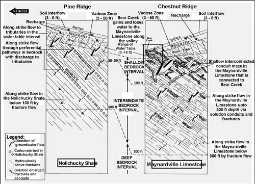
Figure 3-5 Conceptual model for movement of groundwater, surface water, and contaminants
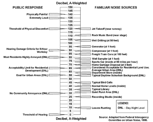
Figure 3-5 shows a conceptual model for the movement of groundwater, surface water and contaminants in BCV (DOE 1997a). The hydrogeology differs significantly between the shale formations (e.g., Nolichucky Shale) and the carbonate formations (e.g., Maynardville Limestone). In BCV, the contact between the Maynardville Limestone and the Nolichucky Shale roughly corresponds to the axis of the valley and marks a major transition from predominantly low hydraulic conductivity shale formations to higher conductivity carbonate formations. Groundwater in the shale formations generally migrates in the direction of the geologic strike (generally from northeast to southeast) until eventually discharging to a tributary of Bear Creek. This surface water can enter the Maynardville groundwater system through losing sections of Bear Creek. Key features of the shale and carbonate formations are discussed in the following paragraphs, followed by a discussion of groundwater quality in the area of the proposed FRC. Flow in Predominantly Shale Formations (e.g., Nolichucky Shale) Although there are no clearly defined abrupt hydrologic and geologic changes in the shale formations with depth, a general hydrologic and geologic stratigraphy can be defined that separates these formations into shallow, intermediate, and deep flow regimes (Figure 3-4). The boundary between shallow and intermediate intervals is defined by a consistent change in groundwater geochemistry at approximately 100-foot (30-m) depth that indicates flow is considerably slower below this depth (Haase 1991; Dreier, Early, and King 1993). The boundary between intermediate and deep intervals is poorly defined and is indicated by a change in groundwater geochemistry that has been observed between about 328- and 492-foot (100 and 150 m) depth (Solomon et al. 1992; Haase 1991; Dreier, Early, and King 1993). Most flow in the shale formations occurs in the shallow interval. This interval includes the water table interval that usually occurs close to the soil-bedrock interface. Most flow in the shallow interval is probably through higher conductivity zones that may exist at the soil-bedrock interface (Solomon et al. 1992) or through other preferential flow pathways in the bedrock. Flow in the shallow interval is oriented predominantly along geological strike, with discharge occurring at the tributaries to Bear Creek. In the intermediate interval, geochemistry data indicate greater groundwater residence times; thus, generally slower flow below 100 feet (30 m). However, the distribution of contaminant plumes in BCV indicates that more rapid flow than predicted by major ion geochemistry may in preferential pathways in this interval and may occur up to 200 feet (61 m) in depth. (Nitrate from the S-3 Site has migrated approximately 0.62 miles [1 km] or more since 1950.) An upward hydraulic gradient occurs almost everywhere in the shale formations that crop out on the southern flank of Pine Ridge. Groundwater in deep formations is hydraulically connected along the bedding planes to recharge areas located up-dip at higher elevations on Pine Ridge. As a result, deeper formations tend to have recharge zones farther up-slope than shallow formations, creating the upward hydraulic gradient. Flow in Carbonate Formations (e.g., Maynardville Limestone) The Maynardville Limestone crops out along the southern side of the BCV floor. This formation and Copper Ridge Dolomite act as a hydraulic drain for the valley. Flow in these formations is predominantly along geologic strike and parallel to the maximum hydraulic gradient. The hydrostratigraphy in the carbonate formations is less well defined than that in the shale formations (Solomon et al. 1992). The shallow interval includes groundwater to approximately 100-foot (30-m) depth. Flow in this interval occurs through a system of interconnected fractures and solution conduits and cavities and is closely associated with flow in Bear Creek. The channel of Bear Creek is one of the main hydraulic conduits in this system. In this interval, groundwater flow is relatively rapid. The intermediate interval occurs between approximately 100-foot and 328-foot (30-m and 100-m) depth. Solution cavities and solution-enlarged fractures exist in the Maynardville Limestone in this interval and are probably well connected by other fractures. Because of its depth, this zone is isolated from dilution effects seen in shallower zones. Thus, flow rates are probably slower than those in the shallow interval, but contaminant plumes are more persistent and extend farther along the valley. This zone constitutes an important contaminant transport pathway. In the deep interval (greater than 328-foot [100-m] depth), flow through fractures dominates groundwater movement, and flow zones become less frequent as fracture density decreases with depth. Groundwater Quality The proposed contaminated site includes portions of the commingled plume of groundwater contamination in the Nolichucky Shale and Maynardville Limestone (490 acre feet [600,000 cubic meters] of contaminated groundwater) that originated predominantly from the S-3 Disposal Ponds and the BY/BY. The BCBG is also a source of groundwater contamination and dense nonaqueous phase liquid (DNAPL) in BCV, but the BCBG is not included in the FRC boundary. Contaminants in the commingled S-3 Disposal Ponds and BY/BY plume include uranium, Tc99, strontium, nitrate, barium, cadmium, boron, mercury, chromium, VOCs and other inorganics and radionuclides. The S-3 Disposal Ponds site is a source of all of these contaminants. The BY/BY site has contributed primarily uranium and VOCs. There are 570 acre feet (700,000 m3) of contaminated groundwater from the S-3 site and 57 acre feet (70,000 m3) of contaminated groundwater from the BY/BY. The S-3 Ponds Site and BY/BY are located on top of the Nolichucky Shale, and historical waste discharges have contaminated groundwater beneath the waste sites. Due to the high dissolved solids contents of the liquid wastes disposed at the S-3 Ponds Site, contamination has migrated to depths as great as 200 feet (60 m) in the Nolichucky Shale. The S-3 Ponds Site is located on a groundwater divide so contamination has migrated both to the west and east. Contaminants migrate away from the waste disposal units through a number of pathways. Contaminated shallow groundwater at sources above the Nolichucky Shale migrates through fractures along geological strike and discharges to tributaries or directly to Bear Creek, causing the tributaries and Bear Creek to become contaminated. Contaminants in deep groundwater in the Nolichucky Shale also migrate through fractures along geologic strike and discharge to tributaries. However, contaminant pathways in the deep groundwater can underflow proximal tributaries and/or springs and be a source of contamination in neighboring tributary subwatersheds. After entering tributaries, contaminants migrate in surface water directly to Bear Creek. Bear Creek intermittently loses and gains water from groundwater in the Maynardville Limestone throughout the length of the valley. Losing reaches of Bear Creek cause groundwater contamination in the Maynardville Limestone. Gaining reaches of Bear Creek are associated with large springs at the base of Chestnut Ridge, some of which have contaminated discharge. Surface water in Bear Creek and shallow groundwater in the Maynardville Limestone constitute 96 percent of water flowing along the valley. Contaminants in these media pathways are quickly diluted by rapid recharge of rainwater and inputs from noncontaminated tributaries. Deep groundwater in the Maynardville Limestone (100- to 300-foot [30 to 90 m] depth) constitutes less than 4 percent of water flowing along the valley. Concentrations of contaminants in this and in the deep groundwater pathway are not attenuated as rapidly as those in shallow groundwater. This pathway is an important source of long distance groundwater transport along the valley. Contaminant concentrations in shallow groundwater in the Nolichucky Shale and the Maynardville Limestone and in surface water are diluted by recharge during storm events, and show seasonal trends of lower concentrations during periods of high rainfall. 3.1.4 Ecological Resources The following section identifies and describes the terrestrial, and aquatic resources that occur in BCV and near the proposed contaminated area and background area. 3.1.4.1 Terrestrial Resources The vegetation of the ORR is primarily second-growth hardwood oak-hickory forest that is mostly distributed on ridges and dry slopes. Virginia and shortleaf pines are also common, particularly in areas that were cleared and farmed before 1942. The ORR provides habitat for a large number of animal species, including about 60 reptilian and amphibian species, more than 152 species of birds (including 32 species of waterfowl, wading birds, and shorebirds), and about 40 mammalian species. Habitats supporting the greatest number of species are those dominated by hardwood forests and wetlands. Wetland areas within the ORR consist mostly of small swampy areas, generally less than 30 feet (9 m) wide, within and around major drainage basins (DOE 1997a). Bear Creek Valley, the location of the proposed FRC, lies outside the main Y-12 Plant complex close to areas of potential ecological sensitivity. Before 1940, most of BCV was cleared and used for agriculture (Southworth et al. 1992). Currently, about 65 percent of the BCV watershed is wooded, with common vegetation being predominantly oak and oak-hickory associations on the upper slopes and ridgetops and planted pine along the creek and floodplain area (McMaster 1967). Old field and grassland habitat zones are also present. Thus elements of the majority of wildlife habitat types and the expected terrestrial fauna found on the ORR occur in BCV (Welch 1989). Hardwood and mixed hardwood/conifer habitats are the most abundant of the habitat types in the Bear Creek watershed, followed by pine plantation and grassland habitats, with considerable riparian habitat along the length of Bear Creek. Species commonly found in these habitats are described in the ecological risk assessment in Appendix G of the BCV Remedial Investigation Report (DOE 1997a). According to the U.S. Fish and Wildlife Service, the gray bat (Myotis grisescens) and the Indiana bat (Myotis sodalis), which are on the federal endangered species list, may inhabit areas near the proposed FRC (Appendix E). Avian species that have been observed on the ORR and may be present in the BCV are the Cooper's hawk (Accipter cooperii) and the sharp-shinned hawk (A. striatus), both listed by the State of Tennessee as threatened; and the red-shouldered hawk (Buteo lineatus), listed by the state as in need of management (Kroodsma 1987, Mitchell et al. 1996). The southeastern shrew (Sorex longirostris), which the state lists as in need of management, and the pine snake (Pituophis melanoleuas), which the state lists as threatened, have been documented in BCV (Mitchell et al. 1996). The Tennessee dace is listed by the State of Tennessee as in need of management, and occurs throughout most of Bear Creek. Its habitat is protected by the State of Tennessee (Starnes and Etnier 1980). Rare plant species that occur in BCV include the Canada lily (Lilium canadense), which the state lists as threatened, and the southern rein orchid (Platanthera flava), which the state lists as a species of special concern. An uncommon aquatic plant, Orontium aquaticum, also occurs in BCV. In addition, the Chestnut Ridge Whorled Horse-Balm Forest, which overlaps the southeast border of the experimental project area, contains ginseng (Panax quinquifolius), which is listed as special concern in Tennessee due to commercial exploitation, and whorled horsebalm (Collinsonia verticillata), which is considered to be globally rare by the Nature Conservancy. Natural communities of concern within this tract include mesic hardwoods. Landscape elements of concern include mature forest, steep slopes, and moist ravines. The Oak Ridge National Environmental Research Park (NERP) serves as an outdoor laboratory and encompasses approximately 22,500 acres (9100 ha) of the 34,516-acre (13,968-ha) ORR. It is one of seven DOE NERPs across the country. A portion of the Oak Ridge NERP overlays the Y-12 area of responsibility, and overlaps with the western and southern portions of the proposed contaminated area and all of the background area. The DOE NERP provide opportunities for environmental studies on protected lands that act as buffers around DOE facilities. They are used to evaluate the environmental consequences of energy use and development as well as the strategies to mitigate these effects. The research parks are also used to demonstrate possible environmental and land-use options. DOE has made a commitment to preserve biological diversity through protection of special habitats on the ORR such as habitat of rare plants or animals, vegetational communities representative of the Southern Appalachians, and vegetational communities uncommon in the area. Special habitats on the ORR are protected through National Environmental Research Natural Area or Reference Area designations. The entire length of Bear Creek, from its beginning in the proposed FRC through the background area, is a designated Aquatic Natural Area. The Chestnut Ridge Whorled Horse-Balm Forest, described in the previous section, is also a designated National Environmental Research Natural Area, as is the Bear Creek Spring Area, which is just south of the western end of the proposed FRC. Species of concern in the Bear Creek Spring Area include tuberculed rein-orchid (Platanthera flava var. herbiola) listed as threatened in Tennessee, golden seal (Hydrastis canadensis) listed as special concern in Tennessee due to commercial exploitation, ginseng (Panax quinqauifolius) listed as special concern in Tennessee due to commercial exploitation, and whorled horsebalm (Collinsonia verticillata) considered to be globally rare by the Nature Conservancy. Natural communities include mesic hardwoods, mixed pine and hardwoods, and meadows. Landscape elements of concern include wetlands, springs, seeps, ponds, mature forests, and forested rock outcrops. The entire ORR, including the Y-12 Area, is designated as a Wildlife Management Area through a cooperative agreement between DOE Oak Ridge Operations and the Tennessee Wildlife Resources Agency. This agreement provides for management of game and non-game wildlife on the ORR. Wildlife management includes game species management (particularly reduction of the white-tail deer herd); species richness management (ensuring reservation wildlife residents are maintained in viable numbers); featured species management (introduction/restoration of native species); threatened and endangered species management (identifying and protecting individuals, habitat, and factors that create and maintain particular habitats); and pest management (evaluating current land uses and those under consideration for potential wildlife problems). A portion of the Y-12 Area, including the western portion of the proposed contaminated area and all of the background area, is open to deer hunting for six days each year. The hunt is conducted to control the deer population and to help minimize the number of deer/vehicle collisions. Turkey hunting began on the ORR in April 1996. The hunt consists of one scouting Saturday followed by two hunting weekends. The turkey hunting area is the same as the deer hunting area on the ORR. 3.1.4.2 Aquatic Resources Nineteen species of fish have been found in quantitative monitoring efforts conducted at seven sites along almost the entire length of Bear Creek; some fish communities have shown evidence of degraded conditions (Southworth et al. 1992; Hinzman et al. 1995). Minnows are the predominant fish found in the upstream reaches of the creek. Downstream of the location of the proposed background area, northern hogsucker (Hypentelium nigricans), white sucker (Catastomus commersoni), and rock bass (Ambloplites rupestris) are more common. The Tennessee dace (Phoxinus tennesseensis), listed by Tennessee Wildlife Resources Agency as in need of management, was found at all sites except near the confluence of Bear Creek and EFPC. Studies have shown that, not only did the number of fish species increase from 1988 to 1993, but the frequency of occurrence also increased between 1984 and 1987. Recent studies conclude that, while much of Bear Creek still has limited fish fauna (low species richness), it is characterized by robust population parameters (high densities and biomass). The benthic invertebrate fauna, which is rich and diverse at the downstream sections of Bear Creek, shows considerable impact near the headwaters. Quantitative sampling of benthic invertebrates showed a pattern of increasing density, biomass, and taxonomic diversity and richness with increasing distance downstream from the uppermost sampling site (Southworth et al. 1992). 3.1.5 Archaeological, Cultural, and Historic Resources Under the National Historic Preservation Act, the National Register of Historic Places (NRHP) was established to protect important cultural resources. A listing in the NRHP provides recognition that a property is of significance to the national, state, or community, and requires consideration in the planning of federal or federally assisted projects. Cultural resources within the Y-12 area of responsibility include seven cemeteries; one prehistoric site, which is not eligible for inclusion in the NRHP and which has an undetermined cultural affiliation; and 22 pre-World War II structures, four of which are eligible for inclusion in the NRHP. A cultural resources evaluation of previously recorded and inventoried sites within portions of the Y-12 area of responsibility has been prepared but has not been published. One of the seven cemeteries, the Currier Cemetery, is located near the western boundary of the proposed background area in BCV. The Cox-Copeland Cemetery and the Douglas Chapel Cemetery are near but outside of the western and northern boundaries of the proposed FRC, respectively. These cemeteries are protected by law, managed by the Y-12 Environmental Management Department, and open to related families. One pre-World War II structure site (852A) is close to the northwestern edge of the proposed contaminated area. No details are available for this site, but it is designated as not being eligible for inclusion in the NRHP. According to the Tennessee Historical Commission, there are no NRHP-listed or NRHP-eligible properties affected by the proposed FRC (Appendix E). 3.1.6 Land Use, Recreation, and Aesthetic Resources As discussed in Section 3.1.1, the proposed contaminated area and background area lie within the BCV, which is located on the DOE ORR in Anderson and Roane counties. The residential section of Oak Ridge forms the northern boundary of the ORR. The TVA’s Melton Hill and Watts Bar reservoirs on the Clinch and Tennessee rivers form the eastern, southern, and western boundaries. Oak Ridge and the ORR are about 23 miles (37 km) west of the center of Knoxville, 12 miles (19 km) southwest of Clinton, and 7 miles (11 km) northeast of Kingston. The area is linked by Interstates 40 and 75, which intersect in Knoxville. BCV, bordered by Pine Ridge on the northwest and by Chestnut Ridge on the southeast, is approximately 10 miles (16 km) long, spanning the distance from the eastern end of the Y-12 Plant to the Clinch River on the west. The eastern portion of the valley is on ORR land and the western portion (i.e., the Grassy Creek watershed) includes TVA and private land. The proposed contaminated area and background area lie solely within the Bear Creek watershed. Recreational uses of the surrounding area include fishing, boating, hunting, and camping. Melton Hill Lake, which delineates the southern boundary of the ORR, is the closest major water body for recreational uses. Major lake recreational areas within a 5-mile (8-km) radius of BCV include Clark Center Park, Melton Hill Park, Solway Public Use Area, Haw Ridge Park, Oak Ridge Marina, and Guinn Road Park. Additional recreational areas include neighborhood parks and civic centers managed by the city of Oak Ridge. Controlled deer and turkey hunts are held annually on the ORR but are not allowed in areas immediately adjacent to the Y-12 Plant or its disposal areas in BCV. Within the footprint of the proposed FRC, there are no recreational uses of Bear Creek. Much of the region in which the proposed contaminated area and background area are located, between the west end of the Y-12 plant and the junction of Bear Creek Road and State Route 95, has second-growth hardwood forest. Near the Y-12 plant, developed areas associated with the S-3 Ponds Site and waste control areas are open and highly visible. Mowed grassy areas surround these more developed portions. Thus, visual resources range from relatively closed forests to developed areas that include waste control areas and storage yards for scrap metal and other materials. 3.1.7 Socioeconomic Conditions Over 80 percent of ORR employees live in five counties surrounding the ORR; i.e., Anderson, Knox, Loudon, Morgan, and Roane counties). The total population of this five-county area was 517,158 in 1992. The total 1997 labor force in the four-county area, excluding Morgan County, evaluated by DOE in 1998 was 280,190. In 1995, the average per capita income for the four-county area was $20,771, while the Tennessee state average was $21,060. Per capita income in the area ranged from $23,107 in Knox County to $18,749 in Roane County. Per capita income in Knox County and Anderson County ($21,621) were higher than the state average, while both Roane County and Loudon County ($19,606) fell below the average income for the state. Per capita income is typically higher in the city of Oak Ridge than in surrounding counties, reflecting the higher level of education in Oak Ridge and the concentration of residents employed by DOE and its contractors (DOE 1992). Recent downsizing at the DOE facilities in Oak Ridge is a concern of local communities, and significant efforts are underway to attract new industries and businesses. (DOE 1999a, DOE 1997b). 3.1.8 Human Health A baseline human health risk assessment has been conducted as part of the BCV Remedial Investigation (DOE 1997a). The data for the entire valley were divided into four functional areas (FAs) for analysis based on location and/or contaminant source. The proposed FRC lies within the Maynardville Limestone and Bear Creek FA and S-3 Ponds Site FA. The contaminants in these FAs are those to which workers at the proposed contaminated area could be exposed. The primary contaminants in the Maynardville Limestone and Bear Creek FA are: nitrate, boron, uranium, strontium, barium, cadmium, manganese, PCE, TCE, 1,2-DCE, and Tc99. The primary contaminants in the S-3 Ponds Site FA are: uranium, TC99, strontium, cadmium, barium, boron, mercury, chromium, VOCs and nitrates, copper, lead, mercury, nickel, vanadium, and zinc. Persons currently visiting or working in BCV include maintenance or sampling workers. They have limited contact with these contaminants, and are protected from exposure to contamination via adherence to Health and Safety Plans, the use of personal protective equipment when necessary, and Occupational Safety and Health Administration (OSHA)/Superfund Amendments and Reauthorization Act (SARA) training. Administrative controls are in place to limit exposure to radionuclides. These include Radiological Control Organization (RADCON) policies, standards, and procedures. Noise Background data on noise levels at the proposed contaminated area and background area are not available. Noise levels 200 feet (60 m) from main thoroughfares such as State Route 95 have been estimated from traffic counts during rush hour to be between 55 and 60 decibels (dB/A). Noise levels at relatively isolated sites within the plant area may be lower than 55 dB/A (DOE 1997b).Potential activities at the proposed contaminated area and background area are listed in Section 2.2.3. Noise associated with potential FRC activities would be produced by well-drilling equipment, compressors, trucks, and generators. Typical noise levels of familiar noise sources are provided in Figure 3-6. 3.1.9 Waste Control Wastes generated at the proposed contaminated area and background area could include small quantities of contaminated groundwater from drilling wells and sampling in contaminated zones; small quantities of excess soil from coring; field laboratory wastes, some of which would be considered RCRA waste; biological wastes; domestic wastes from the offices and laboratories; and sanitary wastes.
Figure 3-6 Typical noise level of failiar noise sources and public responses
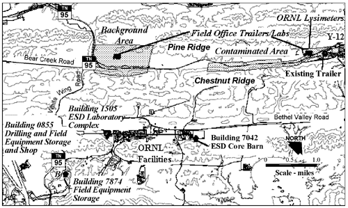
There are existing waste disposal facilities at both ORNL and at Y-12 for the disposal of radioactive, hazardous, chemical, biological, and domestic wastes. The waste generator (e.g., FRC Manager), would work with the ORNL "generator interface" to prepare and submit data packages to BJC to classify the waste stream under the BJC Master Waste Stream Profile. The data package would be reviewed by BJC to ensure that waste acceptance criteria were met. Once the waste certification became official, the waste would be accepted by BJC for final disposition. Waste accepted by BJC would be owned by BJC; they would decide how the waste would be handled, stored, treated and disposed of. Based on current practices, liquid wastes would be treated at the Y-12 West End Treatment Facility (WETF) but ORNL treatment facilities could also be used. Treated water from the WETF is generally discharged to Upper East Fork Poplar Creek. Low level solid wastes are generally disposed of at an appropriate waste disposal facility, such as Envirocare in Clive, Utah. Nonhazardous waste is disposed of at onsite landfills. Any RCRA waste generated by the proposed FRC would be stored in an onsite satellite accumulation area or taken to a 90-day area. 3.1.10 Transportation Much of the proposed contaminated area and parts of the background area are adjacent to Bear Creek Road, which has considerable employee traffic during shift changes at the plant and intermittent traffic during most of the workday. The western boundary of the background area is adjacent to State Route 95, which had existing peak travel volumes of 970 vehicles per hour in 1997 (Table 3.7-2 in DOE 1997b). The Environmental Sciences Division at ORNL currently conducts research at a variety of field sites on the ORR, including groundwater sampling in BCV. Therefore, collection and transport of samples for the proposed FRC would follow existing procedures and meet all environmental, safety, and health (ES&H) requirements. For each new research project that would be conducted at the FRC, the principal investigator would be required to fill out an Environmental, Safety, Health, and Quality Evaluation and complete a Transportation Checklist. Among the items that are detailed in the ES&H evaluation are the movement of soil samples and the transport of samples on public roads. The Transportation Checklist includes questions about the specific activity of the material, its flashpoint, whether or not it is preserved, if samples contain hazardous materials, if the sample is a RCRA waste, and whether there is any question about the hazardous nature or radioactivity of the shipment. Completion of the checklist gives the researcher guidance on the need to contact ES&H specialists in transportation to assist with compliance with appropriate shipping requirements. Transport of samples off the ORR must meet all applicable Department of Transportation requirements for packaging and shipping. 3.1.11 Utilities and Services Electricity for the ORR is provided by the Tennessee Valley Authority. Power is brought onsite via transmission lines currently owned by DOE. DOE withdraws water from the Clinch River at a point south of the eastern end of the Y-12 Plant. The water is filtered and chlorinated at a water treatment plant located north of the Y-12 Plant and distributed to the City of Oak Ridge, the Y-12 Plant and ORNL. This treatment facility provides potable water through two storage reservoirs with a combined capacity of 7 million gallons (26.5 million liters [L]). ORNL operates and maintains an individual sanitary waste treatment plant (SWTP), while the Y-12 Plant uses sewage treatment services at the City of Oak Ridge. The SWTP at ORNL has a current capacity of 300,000 gallons per day (1.1 million liters per day [Lpd]), while the average daily flow to the to the SWTP is less than 200,000 gallons per day (757,080 Lpd). Ancillary facilities would be used to support the proposed FRC. FRC staff and researchers would use existing facilities at ORNL, including offices and research laboratories in Building 1505, drilling and field equipment storage and shop in Building 0855, core barn sample storage in Building 7042, and field equipment storage in Building 7874. At Y-12, there is an existing office trailer near the S-3 Ponds Site that could be used for some FRC purposes. (See Figure 3-7 for locations.)
Figure 3-7 Proposed FRC ancillary facilities 3.1.12 Environmental Justice On February 11, 1994, the President of the United States issued Executive Order 12898, Federal Actions to Address Environmental Justice in Minority Populations and Low-Income Populations. The Executive Order mandates that each federal agency make environmental justice part of the agency mission and to address, as appropriate, disproportionately high and adverse human health or environmental effects of the programs and policies on minority and low-income populations. Approximately 880,000 people live within a 50-mile (80-km) radius of the ORR. Based on 1990 census data, minorities compose about 6 percent of this population, compared to about 24 percent for the nation and 17 percent for the State of Tennessee. No federally recognized Native American groups are present within the 50-mile (80-km) radius (DOE 1999a). The distribution of minority populations and low-income housing data surrounding the ORR is summarized in Table 3-1. The data are provided by census tract in the City of Oak Ridge, the nearest population center to the ORR and the proposed FRC. The minority population data is composed of any census tract within the 50-mile radius with a minority population proportion greater then the national average of 24.4 percent. The low-income household data is composed of any census tract within the 50-mile radius with a low-income population proportion greater than the national average of 13.1 percent.
Table 3-1. Description of the Populations Surrounding ORNL (1990)
*Data calculated by City of Oak Ridge census tracts | ||||||||||||||||||||||||||||||||||||||||||||||||||||||||||||||||||||||||||||||||||||||||
 t
less than 0.82 acre feet (1,000 cubic meters [m3]) of soils
and waste materials on the BCV floodplain contain low levels of contamination.
Contaminants of the soil include uranium, technetium-99 (Tc99),
strontium, nitrate, barium, cadmium, boron, volatile organic contaminants
(VOCs), and other inorganics and radionuclides. Although the proposed
contaminated area is adjacent to most of these waste areas, it actually
includes the former S-3 Ponds Site disposal area and portions of the
BCV floodplain. However, proposed FRC activities would not include drilling
through the S-3 Ponds Site.
t
less than 0.82 acre feet (1,000 cubic meters [m3]) of soils
and waste materials on the BCV floodplain contain low levels of contamination.
Contaminants of the soil include uranium, technetium-99 (Tc99),
strontium, nitrate, barium, cadmium, boron, volatile organic contaminants
(VOCs), and other inorganics and radionuclides. Although the proposed
contaminated area is adjacent to most of these waste areas, it actually
includes the former S-3 Ponds Site disposal area and portions of the
BCV floodplain. However, proposed FRC activities would not include drilling
through the S-3 Ponds Site.